Cascade Volcanoes Aerial Photography Tour: Rainier, Adams, Hood, Jefferson, Three Sisters, Crater Lake, Shasta, Lassen, St. Helens, and more….

Cascade Volcanoes Aerial Photography Tour

Rainier, Adams, Hood, Jefferson, Three Sisters, Crater Lake, Shasta, Lassen, St. Helens, and more....

Region: California, Oregon, Washington
Type: 
Date(s): January 19, 2013 (Sat)
Partner(s): John Scurlock
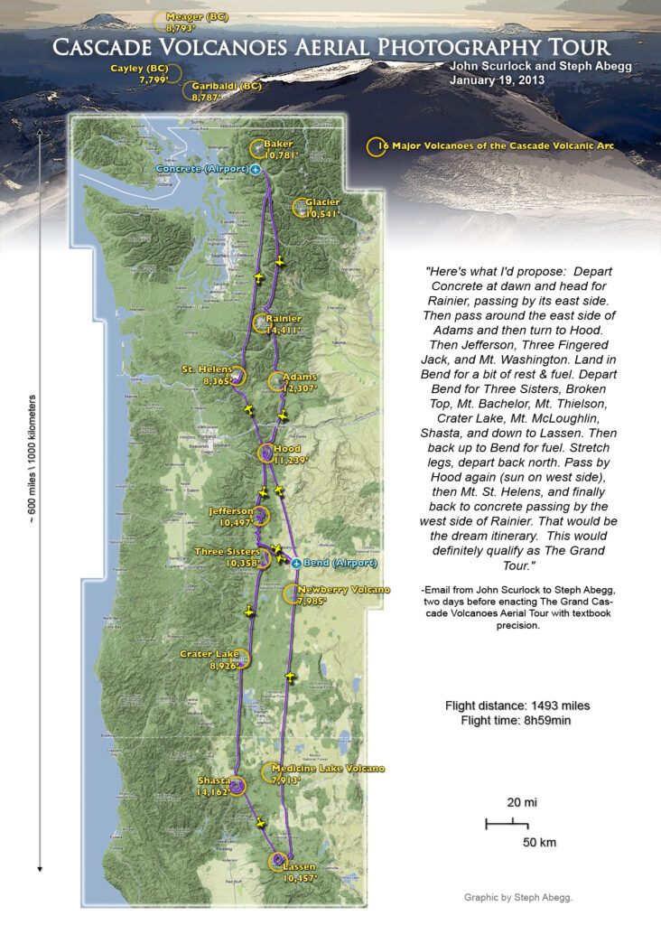
"Here's what I'd propose: Depart Concrete at dawn and head for Rainier, passing by its east side. Then pass around the east side of Adams and then turn to Hood. Then Jefferson, Three Fingered Jack, and Mt. Washington. Land in Bend for a bit of rest & fuel. Depart Bend for Three Sisters, Broken Top, Mt. Bachelor, Mt. Thielsen, Crater Lake, Mt. McLoughlin, Shasta, and down to Lassen. Then back up to Bend for fuel. Stretch legs, depart back north. Pass by Hood again (sun on west side), then Mt. St. Helens, and finally back to concrete passing by the west side of Rainier. That would be the dream itinerary. This would definitely qualify as The Grand Tour."

-Email from John Scurlock to Steph Abegg, two days before enacting The Grand Cascade Volcanoes Aerial Tour with textbook precision. Baker to Lassen, and back in time for dinner. Wow.

Itinerary, Map, Stats

CLICK TO ENLARGE

ITINERARY

7:20 AM : WA: Take-off from Concrete Airport
7:41 AM : WA: Sunrise
8:01 AM : WA: Rainier *
8:23 AM : WA: Adams *
8:50 AM : OR: Hood *
9:13 AM : OR: Jefferson *
9:23 AM : OR: Three Fingered Jack
9:28 AM : OR: Mt. Washington
9:49 AM : OR: Land at Bend AirporT
10:45 AM : OR: Take-off from Bend Airport
11:02 AM : OR: Three Sisters *
11:05 AM : OR: Broken Top
11:44 AM : OR: Crater Lake *
12:27 PM : CA: Shasta *
1:09 PM : CA: Lassen *
2:57 PM : OR: Land at Bend Airport
3:28 PM : OR: Take-off from Bend Airport
4:05 PM : OR: Hood *
4:32 PM : WA: St. Helens *
4:54 PM : WA:Rainier *
4:54 PM : WA:Sunset
5:46 PM : WA:Land at Concrete Airport

(*="major" volcano)

Flight distance: 1,493 miles!
Flight time: 8h59min!


Click on the map to see our flight path, which was made created from the output of a GPS recorder taking a data point of our location at 1 second intervals over the course of the day.

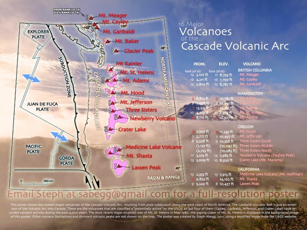
Volcanoes of the Cascade Volcanic Arc

This poster shows the sixteen major volcanoes of the Cascade Volcanic Arc, resulting from plate subduction along the west coast. The Garibaldi Volcanic Belt is just an extension of the Volcanic Arc into Canada. These are the volcanoes that are classified a “potentially active” by the USGS; all but four of them (Cayley, Garibaldi, Jefferson, and Crater Lake) have recorded volcanic activity during the past 4,000 years. The most recent major eruption was of Mt. St. Helens in May 1980; the gaping crater of Mt. St. Helens is displayed in the background image of this poster. Other volcanic formations and dormant volcanic peaks are not shown on the map. I created this 18x24" poster in 2011, using a modified image from the USGS website. See my posters page for more of my interesting poster creations.

Photos


Mt. Rainier 1 (morning)
Mt. Rainier N side (some of the day's objectives—Adams, Hood, Jefferson, and St. Helens—in distance). Little Tahoma on left. 7:59 am
Mt. Rainier E side, casting early morning shadow behind. Little Tahoma in front. 8:03 am
Mt. Rainier SE side in morning light. 8:05 am


Mt. Adams (morning)
Mt. Adams N side (Hood and Jefferson in distance). 8:21 am
Mt. Adams S side (A. G. Aiken Lava Bed in foreground, Rainier in distance). 8:32 am


Mt. Hood 1 (morning)
Mt. Hood S side (Illumination Rock is in front foreground, Adams in distance). 8:53 am
Mt. Hood W side. 8:54 am
Climbers on the standard south side route of Mt. Hood. 8:54 am


Mt. Jefferson (morning)
Mt. Jefferson N side (Three Sisters in distance). 9:14 am
Mt. Jefferson E side. 9:15 am
Mt. Jefferson SE side (Hood in distance). 9:16 am
Mt. Jefferson SW side (Hood in distance). 9:17 am


Three Fingered Jack (morning)
Three Fingered Jack N side (Sisters in distance). 9:23 am
Three Fingered Jack S side (Jefferson in distance). 9:24 am
Three Fingered Jack SW side (Jefferson in distance). 9:24 am


Mt. Washington (morning)
Mt. Washington N side (Broken Top and Sisters in distance). 9:29 am
Mt. Washington S side (Three Fingered Jack and Jefferson in distance). 9:30 am


Three Sisters (mid-day)
What a Lineup! Foreground: South Sister, Middle Sister, North Sister. Distance: Washington, Three Fingered Jack, Jefferson, Hood, Adams, Rainier, & St. Helens. 11:07 am
What a Lineup! labeled pano.
South Sister, Middle Sister, North Sister from the SE (Jefferson in distance). 11:11 am
Three Sisters from SW, with Rock Mesa lava flow and Le Conte Crater in the foreground. 11:12 am


Crater Lake (mid-day)
Crater Lake from the E. 11:45 am
Wizard Island. 11:48 am
Wizard Island. 11:50 am


Mt. Shasta (mid-day)
HWY 97 wrapping around old lava flows on north side of Shasta. 12:26 pm
Mt. Shasta N side. 12:27 pm
Mt. Shasta from NW (Shastina in foreground). 12:37 pm


Lassen Peak (mid-day)
Lassen Peak N side. 1:10 pm
Lassen Peak NE side. 1:11 pm
Lassen Peak SE side (Shasta in distance). 1:12 pm
Cinder Cone and Fantastic Lava Beds, Lassen Peak in distance. 1:27 pm


Mt. Hood 2 (afternoon)
Mt. Hood S side (St. Helens, Rainier, and Adams in distance). 4:06 pm
Mt. Hood W-SW side, afternoon light and shadow behind. (Click here for an annotated version of some of the feature names, created by John Scurlock.4:14 pm


Mt. St. Helens (late afternoon)
Topless Mt. St. Helens SE side. 4:32 pm
Mt. St. Helens S side, with faux Rainier summit. 4:34 pm
Mt. St. Helens W side, looking over the crater towards Adams. 4:36 pm
Mt. St. Helens NW side, looking over the crater towards Hood. 4:37 pm
Ski tracks right up to the crater rim. 4:39 pm
Looking over the crater towards Spirit Lake and Rainier. 4:39 pm


Mt. Rainier 2 (evening)
Swimming sunlit lenticulars in the wake of Mt. Rainier. 4:52 pm
Mt. Rainier W side, casting sunset shadow behind. 4:57 pm
Mt. Rainier W side, alpenglow and and colorful clouds above. 4:59 pm
Mt. Rainier W side, alpenglow and colorful clouds above. 5:00 pm

More Aerial Photography

Wow. Thanks John for sharing your aerial world with me.
Go to my Aerial photography page to see more awesome aerial adventures with John.