Track Statlu Lake drive.gpx: GPS track taken while we drove the forest service roads to the trailhead, July 2017.
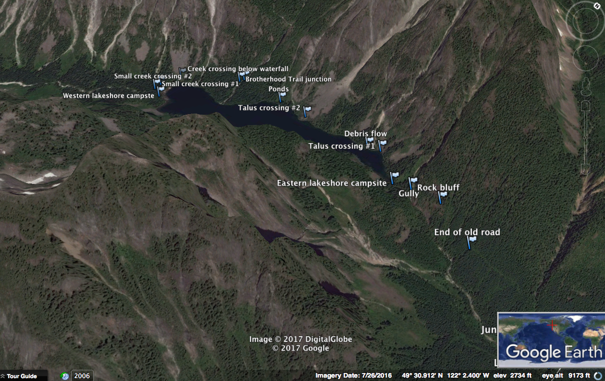
Track Statlu Lake hike.gpx: provides waypoints to the approach from the car to Statlu Lake, originally posted onClubTread.com after the landslide (sometime after 2007).
Intro
THIS TRIP REPORT IS STILL MOSTLY IN THE EMBEDDED HTML FORMAT OF MY OLD WEBSITE. MOBILE Tip: Try Landscape mode. It is generally more mobile friendly.
Approaching Viennese
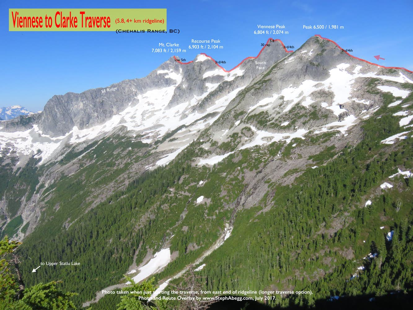
Photo taken when just starting traverse, from east end of ridgeline (longer traverse option). From close to far away (right to left): Peak 6500, Viennese, Recourse, Clarke.
Last summer (2016), my friend DR mentioned that he wanted to climb in the Chehalis Range. I had never heard of the Chehalis Range or any of the peaks in it (Bardean, Viennese, Clarke, Grainger, among others) but DR seemed pretty interested in it, and upon reading the section for the area in the Alpine Select guidebook, I became very interested in the Chehalis Range as well. The Alpine Select guidebook claims that the Chehalis Range offers one of the finest collections of difficult alpine routes in British Columbia—long, demanding rock climbs that test the alpinist's skill, with many long north face climbs on superb rock, magnificent ridge traverses, and spectacular crack climbs. So DR and I made plans to head in there and check it out.
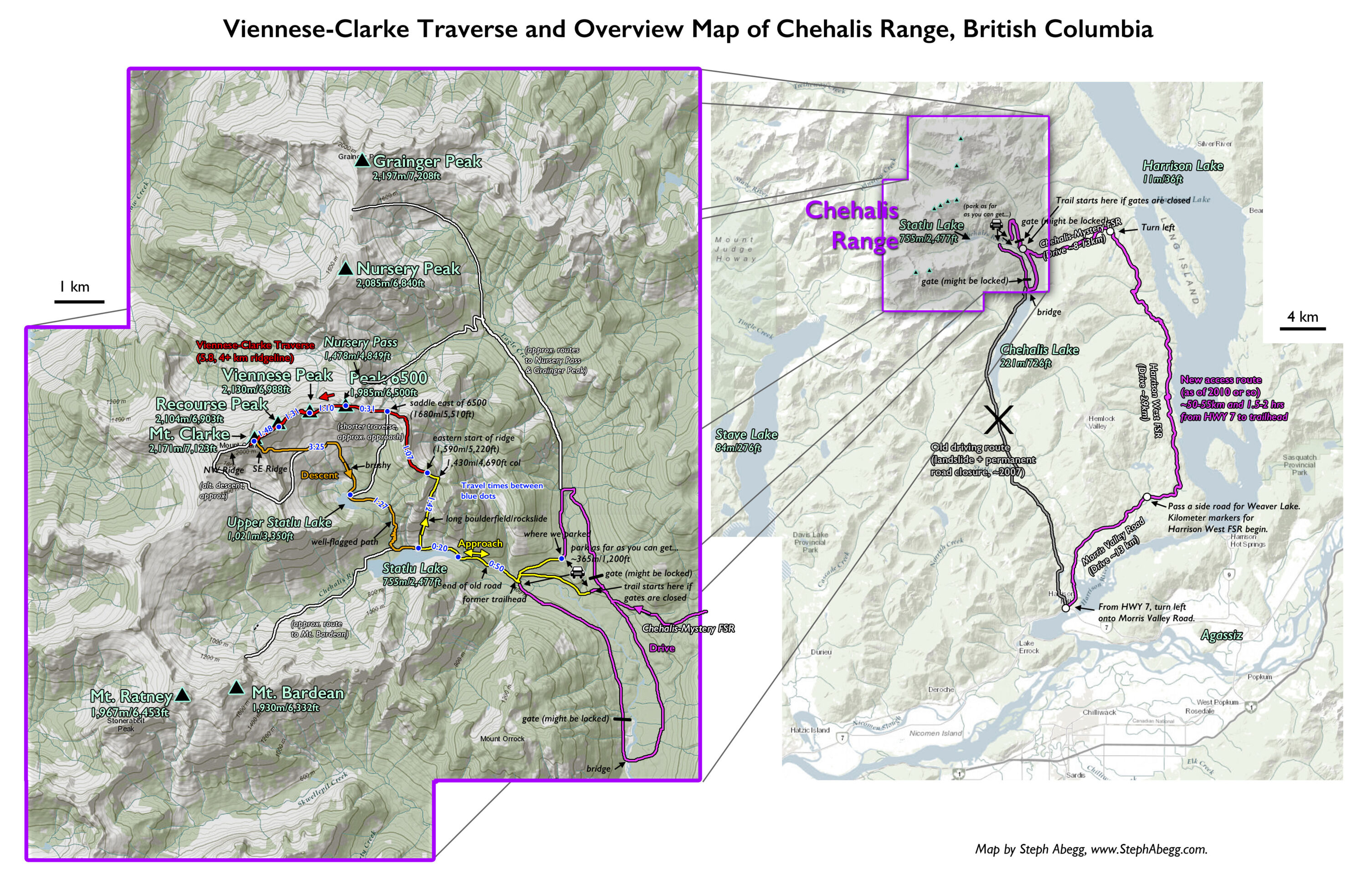
Although the Chehalis Range is located only 45 kilometers northeast of Chilliwack, just west of Harrison Lake, getting into this area has historically been difficult, requiring a 4wd vehicle and several miles of hiking of overgrown logging roads. But the access was drastically changed when a landslide (Dec 2007) into Chehalis Lake resulted in permanent closure of many of the roads in the area (YouTube has a pretty interesting simulation of the landslide and resulting 6m tsunami that hit the opposite shoreline: https://youtu.be/X3LuT1lP00c). As a result of the landslide, a new access trail was built that can be accessed by logging roads from the west side of Harrison Lake. It turns out that this new access provides a much easier way into the Range. In fact, as this trip report shows, easy enough access that you can bring a 2wd vehicle and climb car-to-car*! (*Only a handful or routes—including the one we did—would be feasible car-to-car; most of the rock routes would still require establishing a camp closer to the climb.)
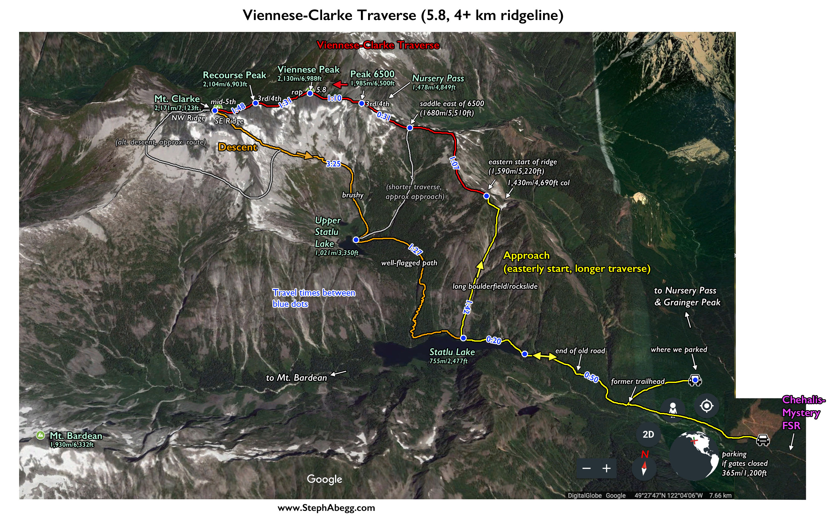
DR and I decided to do the Viennese-Clarke Traverse. This high ridgeline traverse would be a great way to do a reconnaissance of the range for future climbing in the area. Plus, according to the Alpine Select guidebook, the Viennese-Clarke Traverse is one of the finest moderate alpine routes in British Columbia, featuring a high ridgeline traverse with awesome exposure and superb terrain. The Traverse is a counter-clockwise circular loop, east to west along the summits. The main technical difficulties (up to 5.8) are on the ascents of the east ridges of Viennese and Clarke. Although overall there is little technical difficulty above mid-5th, the Traverse is quite athletic and requires moving efficiently over lots of 3rd and 4th class terrain. The guidebook recommends bivying at the start of the ridge and finishing at Upper Statlu Lake (for a total of 10km of rugged terrain); but we did the traverse car-to-car, doubling the amount of distance travelled and climbing directly up to the high ridge due north of Statlu Lake and accessing the traverse from here. It was a long day (17 hours) but much preferable to hauling heavy overnight loads in partway.
DR and I both thought that the Viennese-Clarke Traverse was indeed excellent. One thing that stood out is how excellent the rock was. I definitely plan to return to check out some harder routes on the nearby summits.
The following page contains some useful overlays and GPX files, time stats from our traverse, and some photos from the traverse.
Time Stats
Total car to car time (includes breaks): 17 hours (5am-10pm)
=drive =approach =traverse =descent
Where to where
Clock times
Elapsed time
Notes
Drive from HWY 7 to where we parked
6:10-9:00pm
2:50
We checked out all of the trailhead options, actual drive can be done in 1.5 hours from HWY 7
Car to East end of Statlu Lake
4:53-5:50am
0:57
We missed the trailhead and went to far by a few minutes and had to backtrack, so without this abut 50 minutes to lake.
East end of Statlu Lake to boulderfield/rockslide on north side of lake
5:55-6:15am
0:20
Statlu Lake (start of boulderfield/rockslide) to Col
6:15-7:31am
1:16
efficient way to gain 675m/2,200ft of elevation
Col to Start of Ridge
8:03-8:30am
0:27
Start of Ridge to saddle just east of Peak 6500 (alt. start to traverse)
8:41-9:48am
1:07
This section of the traverse is part of the more easterly start / longer traverse option.
Saddle just east of Peak 6500 to Peak 6500
9:48-10:19am
0:31
easy scrambling
Peak 6500 to Viennese
10:38-11:48am
1:10
3rd and 4th, with a short 5.8 to low 5th pitch directly below the summit of Viennese
Viennese to Recourse
11:48am-1:19pm
1:31
1 rappel off Viennese followed by 3rd and 4th to Recourse
Recourse to Clarke
1:30-3:18pm
1:48
3rd and 4th, with about 600 feet of mid-5th up the final headwall of Clarke (we did 2 pitches and then soloed).
Clarke main summit to Clarke west summit
3:18-3:38pm
0:20
It is not necessary to go to the west summit if you descend the SE Ridge, but we wanted to go all the way to the end of Clarke to feel like we completed the traverse of the summits.
Clarke main summit to Upper Statlu Lake via SE Ridge
4:00-7:25pm
3:25
We didn't take the most ideal route. We came down too far right when coming off SE Ridge and had to do some sketchy downclimbing, and we missed the best path to Upper Statlu and got entangled in some bushwhacking.
Upper Statlu Lake to East end of Statlu Lake
7:25-9:12pm
1:47
We stayed on a well-flagged path the entire way.
East end of Statlu Lake to Car
9:18-10:03pm
0:45
It was dark enough for headlights just as we left the lake.
Car to HWY 7
10:30pm-12am
1:30
Photos
Photos:
Photo descriptions:
Approach
Drive
1.
2.
3.
4.
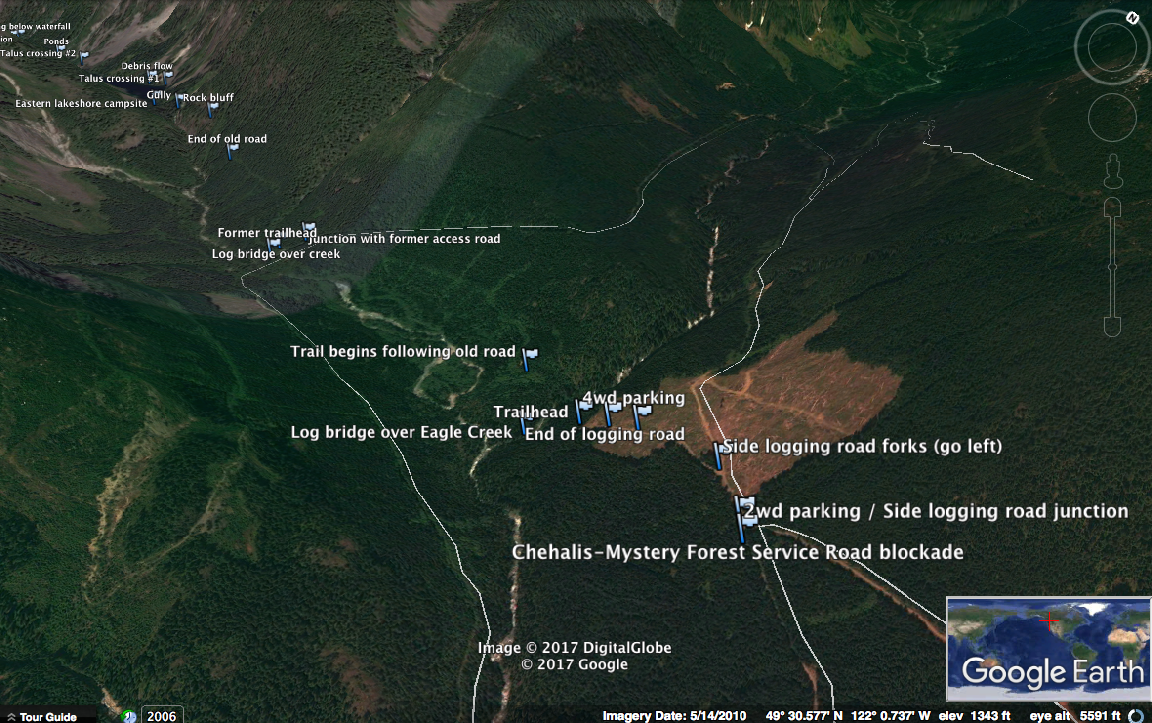
1.A photo of the turnoff for Mystery-Chehalis Forest Service Road. As shown in this photo, the logging roads are all in excellent shape (besides a pothole or washboard here or there) and 2wd.
2.The usual option for the start of the hike to Statlu Lake. Here you walk down an old logging road and then along the creek for a bit until you get to the old Statlu Lake trailhead. Statlu Lake is probably about 1.25-1.75 hour hike from the car. 3.You can potentially drive a bit closer to Statlu Lake than the usual spot shown in the previous photo. There are two ways (see my overlay map for route lines showing all the places you can park your car). One option is to drive south from the usual trailhead and cross the bridge near the head of Chehalis Lake and drive up a new logging road along the west side of the valley. However, this road was gated as of July 2017, but the guy we talked to at the gate (who worked for the logging company) said that the gate might be open by the end of the summer, once the logging is finished. The end of the road is at the old trailhead for Statlu Lake; from here Statlu Lake is about a 35 minute hike. 4.The second option to get a bit closer to Statlu Lake is to drive north from the usual trailhead and take a logging road that wraps back around heading towards the old trailhead for Statlu Lake. Drivability ends about 1km from the old trailhead for Statlu Lake. This road also is gated, but the friendly gatekeeper allowed us to drive through and park up there during our climb. This probably saved about 30 minutes from the approach.
Approach
Car to Ridge
5.
6.
7.
8.
5.This is the old trailhead for Statlu Lake, marked with a stone arrow. 6.Just before reaching Statlu Lake there is a giant waterfall, and a tempting slab to walk across to go and have a peek. But unfortunately you cannot quite see the waterfall from a safe location on this slab. Beware, this has been the location of a fair share of fatalities. 7.The long boulderfield/rockfall area leading up to the 1430m col above Statlu Lake. This is the way we went, to access the east end of the ridge and do the longer traverse described in the Alpine Select guidebook. This rockfield is an efficient way to gain 2,200 feet of elevation. The east end of the traverse starts just above and north of the col. 8.Views of Bardean and Ratney to the southwest. There are a couple of routes on Bardean I am interested in.
Traverse
Start of Ridge to Clarke
9.
10.
11.
12.
13.
14.
15.
16.
17.
18.
19.
20.
21.
22.
23.
24.
25.
26.
27.
28.
9.Easy strolling at the start of the ridge traverse. We accessed the far east end of the ridge for the longer traverse option described in the Alpine Select guidebook.
10.Approaching Peak 6500. Several parties access the ridge at the saddle shown in the photo and start the traverse from there.
11.Nearing the summit area of Peak 6500. As you can see in the photo, the rock in this area is quite nice.
12.A view toward Viennese from the top of Peak 6500.
13.Scrambling towards Viennese.
14.Exposure increases as you get closer to the summit of Viennese.
15.Just before the summit, you traverse across a slab on the left, step past a couple of large chockstones, and climb a short 5.8 face followed my mid-5th to the top. We roped up for this 5.8 bit and just did one pitch to the top.
16.To get off the summit of Viennese and continue the traverse requires one rappel. The tat at the anchor was in pretty good shape.
17.Looking back up towards the summit of Viennese from the west after the rappel. The rappel takes you down to the obvious diagonal horizontal break which you the scramble across to the ridge. Beta: This rappel requires a 60m rope. This is one of the few rappels on the route (another is optional getting to Clarke and will need to rappel at least once on the descent from Clarke).
18.The next section of ridge after Viennese.
19.Looking down at the sheer north face of Viennese. I really want to return and climb Derektissima (10a) which climbs cracks up this face.
20.View of Grainger Peak to the north. There are a couple of routes I want to climb on Grainger as well.
21.DR on the ridgecrest, headed towards Recourse.
22.Recourse. Notice the cornice.
23.Looking back towards Viennese. 24.Mt. Clarke as seen from top of Recourse.
25.The final headwall of Mt. Clarke. The Alpine Select guidebook calls this mid-5th, but we found just the first half had 5th class climbing. We did the first half as two 55-m pitches, and then soloed the rest (4th) to the top.
26.A short section of splitter cracks on our first pitch.
27.DR on top of Clarke.
28.Looking west down the ridge from the top of Clarke. For completeness of the traverse, we continued along the ridge to tag the lower western summit of Clarke shown in the photo, but then backtracked back to the main summit in order to descend the SE Ridge. The NW Ridge descent would continue over the lower western summit and descend into the basin on the other side. The NW RIdge is supposedly more aesthetic than the SE Ridge and also maintains the line of the traverse, but we decided it was wise to choose the faster descent, given in was already 4pm and we did not want to be trying to find faint trails and navigate unknown terrain the dark.
Descent
Clarke to Car
29.
30.
31.
32.
33.
34.
35.
36.
37.
38.
29. Looking down the SE Ridge, which we descended. This is a 3rd class scramble (if you stay on route).
30. Looking down off the east (left) side of the SE Ridge. The idea is to descent 3rd class ledges until just above the glacier, and only need to do one rappel. I think the best route goes off skiers left of this photo. 31. We made one rappel off a tree and did some rather exposed, sketchy downclimbing. I think an easier route existed more skiers' left of us. 32. The bergshrund. Pretty easy. 33. Descending snow slopes into the basin below. 34. Descending towards Upper Statlu Lake. 35. Somehow, we missed the correct descent path and ended up in a sea of alders. 36. This would have been a bit easier to descend.... 37. The trail between Upper Statlu Lake and Statlu Lake was well-flagged. 38. Bears in the area...
Useful beta. Updated route information. Corrections. Historical notes. Interesting facts. No fluff please. Please do not put links in your comment, as my spam filter will filter those comments out.