Yoho NP 2010: Yukness, Hungabee West Ridge, Huber Huber Ledges to Northeast Face

3 Climbs in Yoho National Park

Routes:

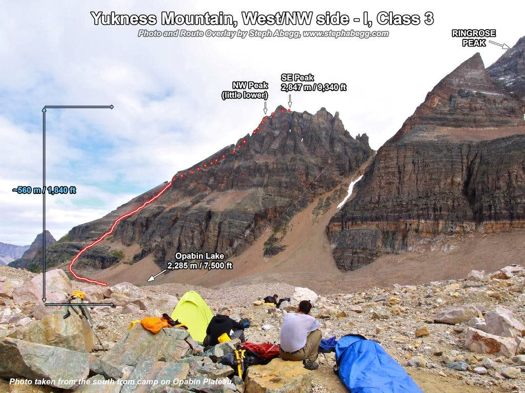
- Yukness Mountain, W/NW Side (3rd)
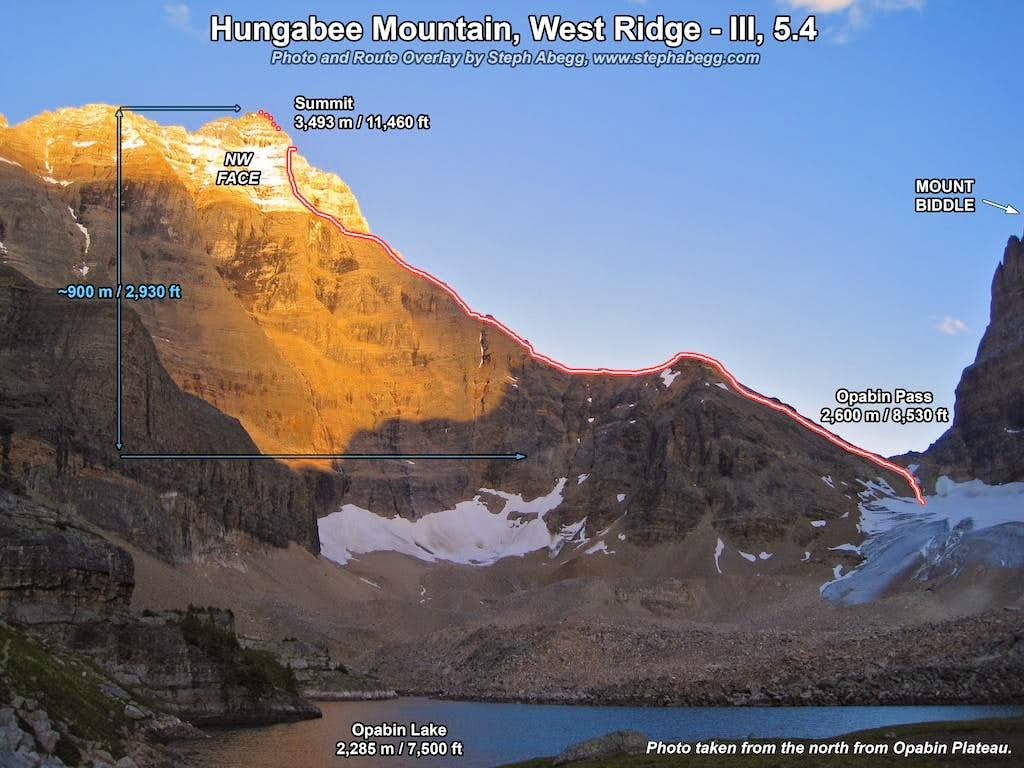
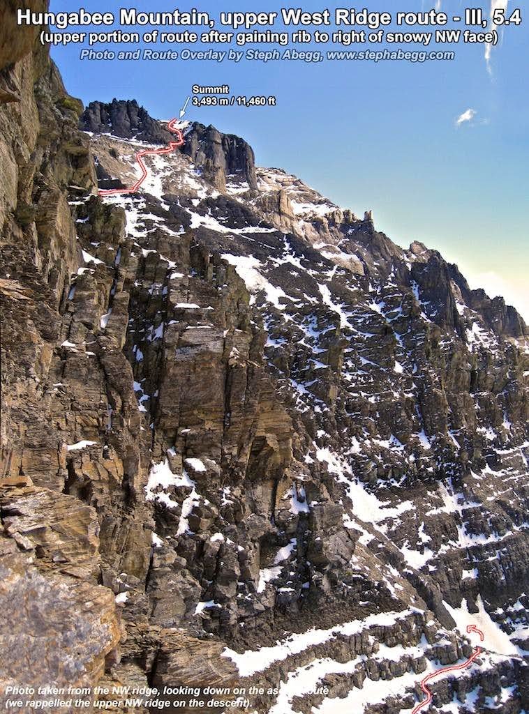
- Hungabee Mountain, West Ridge (5.4)
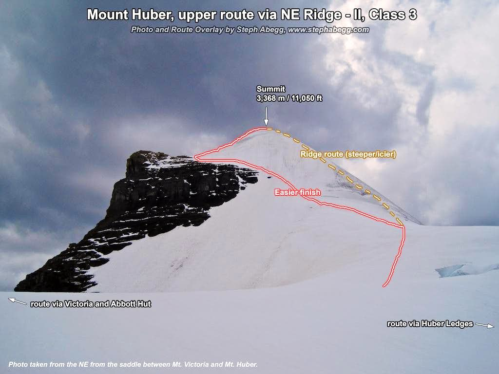
- Mt. Huber, Huber Ledges to NE Face (3rd)

Three big Canadian Rockies summits in Yoho National Park.

Region: British Columbia
Elev: 2,850 m / 9,350 ft (Yukness); 3,490 m / 11,460 ft (Hungabee); 3,350 m / 10,980 ft (Huber)
Rock type: Shale, Quartzite, & Limestone
Type: 
Date(s): August 24-26, 2010 (Tue-Thu)
Partner(s): Scott Bingen, Demetri Galaxides, Steve Trent

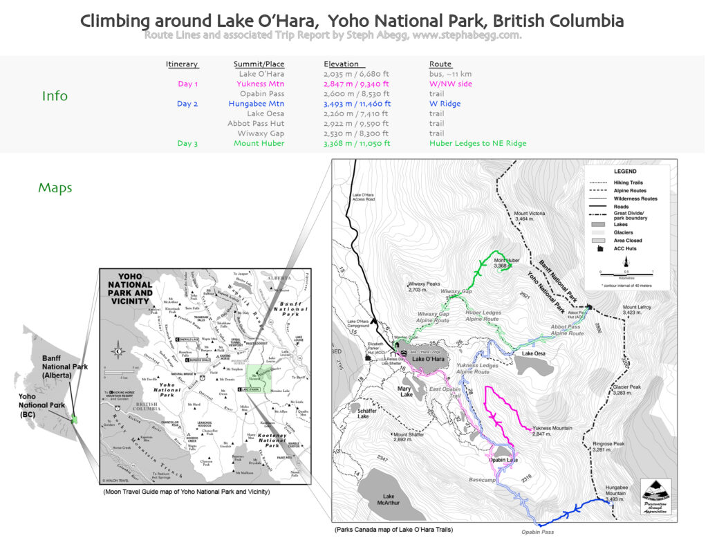
Route Overlays & Map

CLICK TO ENLARGE

Labelled Panorama

Yukness Mountain offers a spectacular 360° view of the SE corner of Yoho National Park. I created this panorama by stitching together 10 images. I labeled the peaks as well.

CLICK TO ENLARGE

Intro

THIS TRIP REPORT IS STILL MOSTLY IN THE EMBEDDED HTML FORMAT OF MY OLD WEBSITE.

Yukness Mtn
W/NW Side
Hungabee Mtn
W Ridge
Mt. Huber
Huber Ledges to NE Face
Abbot Pass Hut
via trail
Me (Steph)
Seattle, WA
Scott
Anacortes, WA
Steve
Anacortes, WA
Demetri
Canmore, AB

It's always fun to check out a new climbing area, so I jumped at the chance to join my friends Scott and Steve on a climbing trip to the Canadian Rockies. We were disappointed that the weather forecast was not solid enough for Mt. Robson, but we decided that climbing some massive Rockies 11'ers in Yoho National Park would be a worthy alternative. Yoho National Park is located along the western slope of the Continental Divide in southeastern British Columbia, and is bordered by Banff National Park (Alberta) on the eastern side.

We spent three days climbing in the beautiful Lake O'Hara area of Yoho National Park:

  1. The first day (Aug 24) we took the bus to Lake O'Hara (avoids walking 11km along road), hiked a couple of hours to the basin below Opabin Pass where we established camp, and then scrambled up Yukness Mountain for some stellar views of the park. A friend named Demetri (from Canmore) joined us.
  2. The second day (Aug 25) the four of us (Scott, Steve, Demetri, and I) climbed the West Ridge of Hungabee Mountain, which is the highest summit in Yoho National Park and lies on the continental divide between BC and Alberta. Climbed only a couple of times a year, this mountain represents the epitome of Rockies climbing: massive, chossy, tricky route-finding, and spectacular summit views. We had reservations at Abbot Pass Hut, so despite the fact we got down to camp as the sun was setting, we packed up to hike 3.5 hours to Abbot Pass. Demetri had to work the next day, so he hiked out. The grueling ascent in the dark was all worth it when we were greeted with a fire burning in the wood stove and water already boiling on the stove.
  3. The third day (Aug 26) we woke up to a brilliant morning at the cozy Abbot Pass Hut. After the long day the day before, it was nice to just hang out in such a beautiful spot. But after about 30 seconds of relaxing in the hut, I began to get antsy to climb some of the mountains towering around us. So I left to go climb Mt. Huber (via the Huber Ledges route, since I preferred to have a partner if I went up the more technical route from Abbot Pass), while Scott and Steve opted to hang out at the hut.  I reconnected with Scott and Steve evening at the Lake O'Hara parking lot, and we drove to Canmore to stay with some friends. (Finally, before heading back to Seattle, we climbed the southwest ridge of Mt. Temple in Banff NP with the Canmore friends.)

This page provides photo trip reports for the three climbs. Although I do not give a detailed verbal description of the climbs (there are several good guidebooks that have good descriptions), each photo has a short description. I've also included some maps and route overlays. (Note that Hungabee, Huber, and Abbot Hut lie on the continental divide between Yoho NP (BC) and Banff NP (Alberta); we approached via the Yoho NP side, but there are also routes that approach from the east.)

Climbs We Did

CLICK ON ROUTE TO DROP DOWN CONTENT

Summit 1
Yukness Mountain, W/NW Side
date: Aug 24, 2010
partner: Scott Bingen, Steve Trent, Demetri Galaxidas
elev: 2,847 m / 9,340 ft
lat/long: 51.34500, -116.30500
difficulty: I, Class 3
time: 1h30min from Opabin Basin to summit, 1h15min from summit to Opabin Basin
Easy scramble to a great 360° view.

Photos from climb

Summit 2
Hungabee Mountain, West Ridge
date: Aug 25, 2010
partner:
Scott Bingen, Steve Trent, Demetri Galaxidas
elev: 3,493 m / 11,460 ft
lat/long: 51.33310, -116.28420
difficulty: III, 5.4
time: 5h from Opabin Pass to summit, 7h from summit to Opabin Pass (would be faster if not rappelling)
This climb to the highest summit in Yoho National Park represents the epitome of Rockies climbing: massive, chossy, tricky route-finding, and spectacular summit views.

Photos from climb

Summit 3
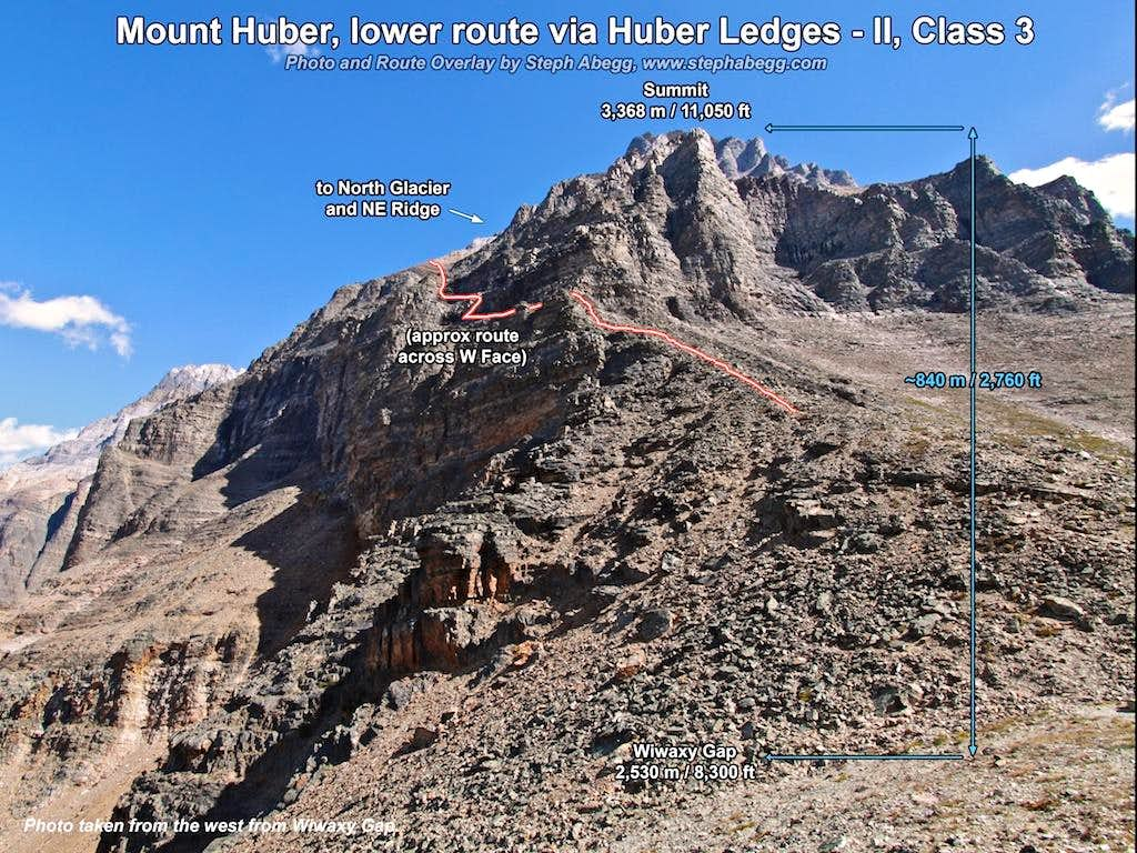
Mt. Huber, Huber Ledges to NE Ridge
date: Aug 26, 2010
partner:
solo
elev: 3,368 m / 11,050 ft
lat/long: 51.37028, -116.31223
difficulty: II, Class 3
time: 40min from Abbot Pass to Wiwaxy Gap, 2h10min from Wiwaxy Gap to summit, 2h30min from summit to Lake O'Hara
A fun climb across an improbable west face.

Photos from climb

Abbot Pass Hut

We spent our second night at the Abbot Pass Hut, nestled in a stunning position at Abbot Pass (2925 m / 9,598 feet) between Mt. Victoria and Mt. Lefroy. The roofline of the hut is on the continental divide on the boundary between Banff National Park in Alberta and Yoho National Park in British Columbia.

The hut was originally built in 1922 by Swiss guides working for the Canadian Pacific Railway to shelter clients attempting to climb Victoria and Lefroy. Much of the construction material was carried from Lake Louise on horseback across the Victoria Glacier and winched or carried on guides' backs up the pass on a route known as The Deathtrap because of its exposure to avalanches and crevasses. The CPR operated the hut for 40 years, and in the 1960s turned the operation over to Parks Canada, which renovated it with the help of volunteers. In 1985 Parks Canada turned the hut over to the Alpine Club of Canada. Reservations, a $26 fee (2010 price), and strong legs are all that are required to stay overnight at this amazing spot. The hut sleeps 24 on its upper floor and has a wood stove, a kitchen stocked with propane and utensils, and an outhouse.

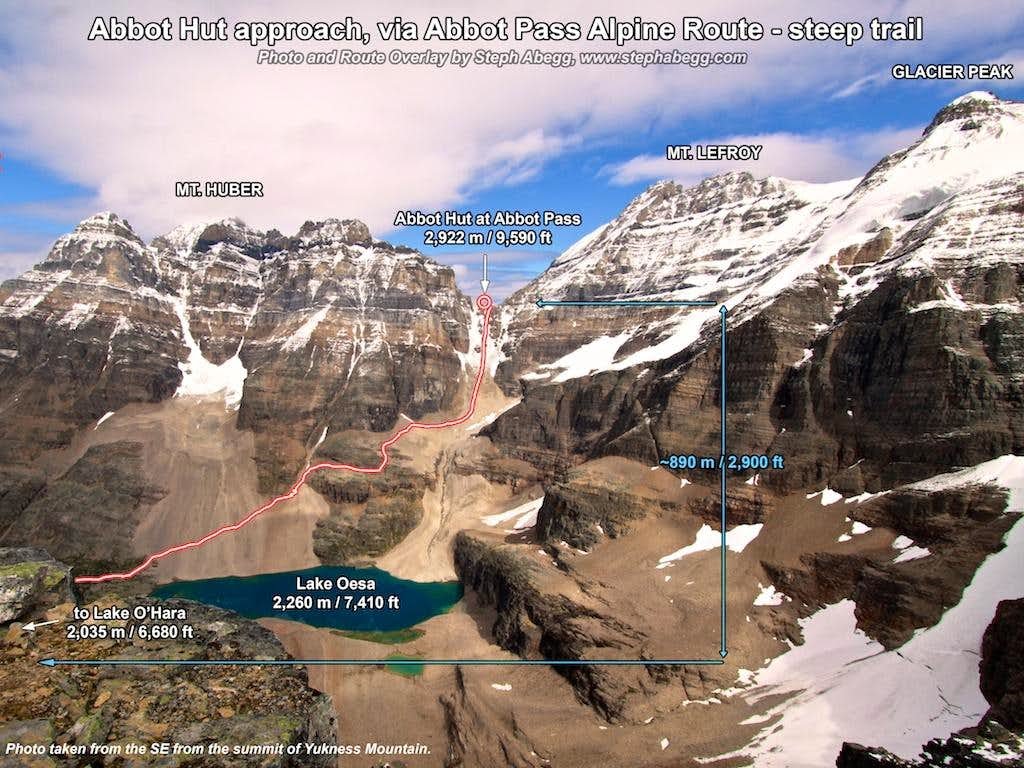
The Abbot Pass Hut can be approached from either the Lake O'Hara area on the British Columbia side (hiking past Lake Oesa), or the more technically demanding route from Lake Louise on the Alberta side. We ascended the trail from Lake O'Hara side, which gains about 890m/2900ft from Lake O'Hara. Below is a photo route overlay of the route to Abbot Pass from the Lake O'Hara side.

Below are some photos from the Abbot Pass Hut. The moon was just cresting the ridge when we arrived at the hut, so I took some moonlight photos before going to bed.


Hiking and camping around the Lake O'Hara area

Below are some miscellaneous photos from our three days spent hiking and camping around the Lake O'Hara area of Yoho National Park. It is a gorgeous area to go to even if you are not a climber. There are numerous hiking trails. There is a bus shuttle and camping in the area, which require reservations.

Comments Pertaining to this Page / Trip Report

Useful beta. Updated route information. Corrections. Historical notes. Interesting facts. No fluff please.
Leave a Reply

Your email address will not be published. Required fields are marked *