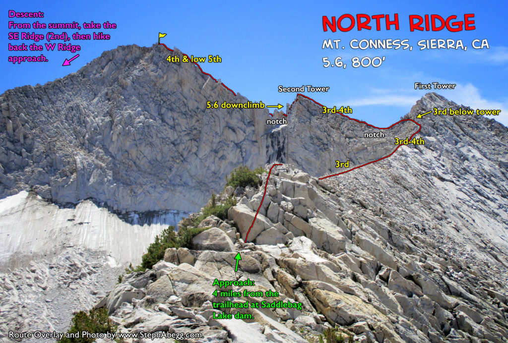
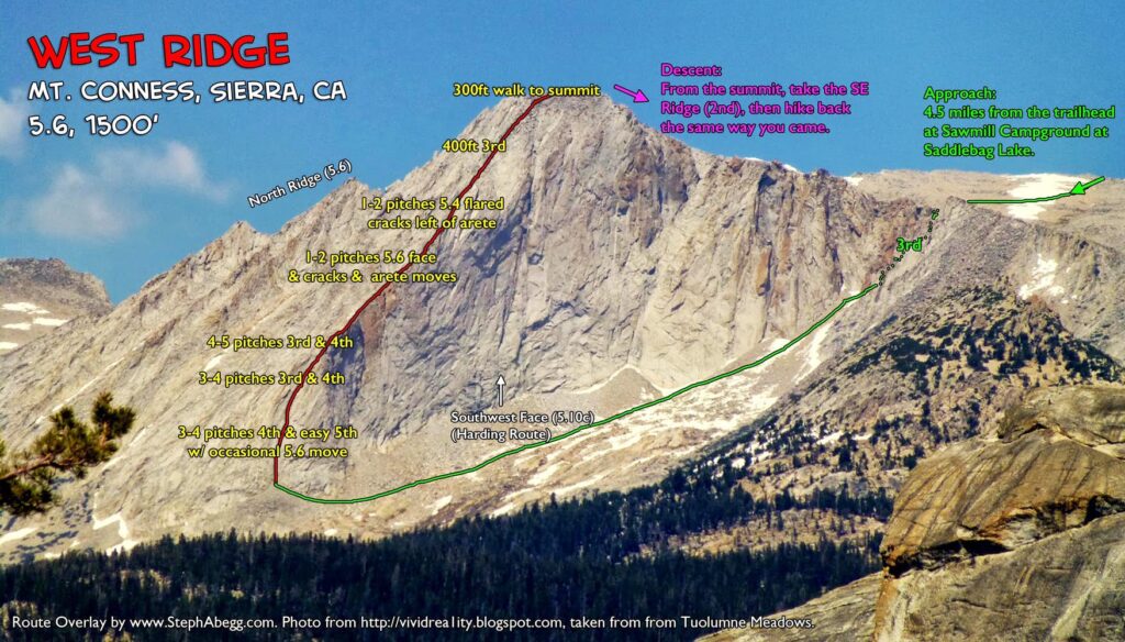
Conness, West Ridge (5.6, 1500′, solo ascent) to North Ridge (5.6, 800′, solo descent)

Mt. Conness

Routes:

- West Ridge (5.6, 1500', solo ascent)
- North Ridge (5.6, 800', solo descent)

West Ridge up, North Ridge down.

Region: California
Elev: 12,950 ft
Rock type: Granite
Type: 
Date(s): August 3, 2015 (Mon)
Partner(s): Sarah Inwood (West Ridge) & solo (North Ridge)

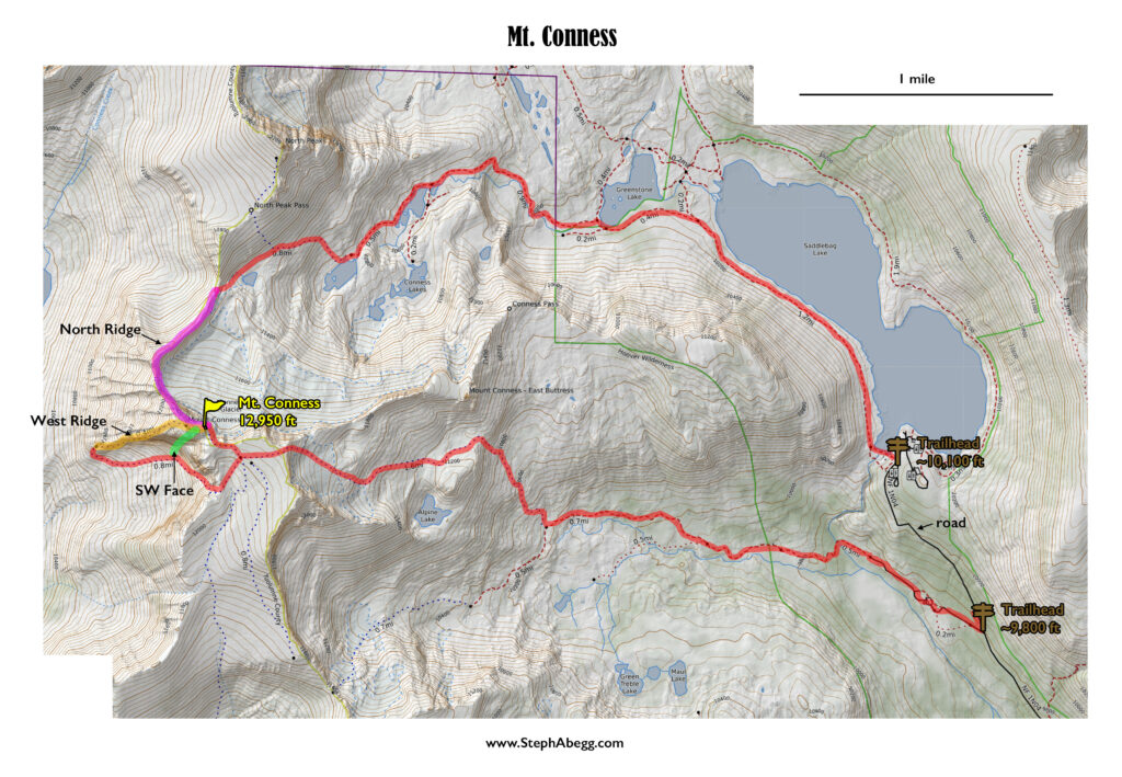
Route Overlays

CLICK TO ENLARGE

Intro

"Hey...are you a climber?....are you looking for a climbing partner for a few days?..." And that was how I met Sarah in the Mammoth Lakes Library. It turned out were both Stanford alums (she had started grad school there the year after I finished my undergraduate degree), and we had several mutual friends/climbing partners in the Stanford Alpine Club. So we hit it off quickly. Sarah and I proceeded to spend the next two days cragging in Pine Creek Canyon, a beautiful granite canyon located in the Sierra foothills between Bishop and Mammoth Lakes. After a couple of days of cragging, Sarah proposed we climb the West Ridge of Mt. Conness to give our arms a rest and get a cardio workout. Sure!, I said.

The West Ridge of Mt. Conness is one the best moderate alpine climbs in Tuolumne. In fact, Peter Croft called it the best route he had done in the Sierra backcountry (albeit before embarking on some of his recent mega-traverse-linkups). Most of the 1500' (vertical) route is 3rd and 4th class, with the most difficult climbing in the first two pitches which are rather sustained 5.6. The moderate level of difficulty makes this a great route to solo if you are comfortable with that sort of stuff. Sarah and I soloed it.

Sarah and I parted ways at the summit to descend by two different routes: Sarah by the standard SE ridge walk-off and me by the North Ridge. The North Ridge is also a popular moderate climb on Conness. Like the West Ridge, this route is rated 5.6, and is composed of long stretches of 3rd and 4th class occasionally interrupted with an exposed 5.6 move. By descending the North Ridge you get two classic routes in one day!

This was a super fun day—a wonderful way to stretch the legs and be treated to awesome views of Tuolumne the whole time. Since we were soloing, our packs were light and we moved pretty fast on the rock. Timewise, it took Sarah about 7.5 hours car-to-car for the West Ridge with standard descent and it took me about 8.5 hours car-to-car for my West Ridge to North Ridge link-up (break-down below). Long enough for a good work-out, but short enough that we were back at the car by early afternoon with plenty of time and energy to pack for the Incredible Hulk the next day....

Below are a couple of route overlays and some photos from the day. Thanks Sarah for the excellent suggestion and great company!

Time Stats

Approach to West Ridge (Sawmill Campground to base of West Ridge): 3:30
West Ridge (base of ridge to summit): 1:48
Standard hike out (summit to Sawmill Campground): 2:00
Descent of North Ridge (summit to base of North Ridge): 1:15
Hike out from North Ridge (base of North Ridge to dam at end of Saddlebag Lake): 1:35

Photos

THIS TRIP REPORT IS STILL MOSTLY IN THE EMBEDDED HTML FORMAT OF MY OLD WEBSITE.

PhotosPhoto descriptions
Approach to West Ridge
1.    
2.    
3.    
4.    
5.    
6.    
7.    
8.    
9.    
10.    
11.    
   
1. Dilapidated shed of the Carnegie Institute.
2. Sarah pointing out the saddle we will pass through.
3. You pretty much go up just right of the high point in this photo. The summit of Conness is not visible in this photo.
4. The summit of Conness is on the right. Now that you're practically on top, you drop down off the plateau.
5. Sarah taking in the view. From here you can see almost all of the major Tuolumne domes.
6. Me standing at the edge of the plateau gazing at the steep SW Face of Conness. This is the location from which you drop down to hike below the SW Face to the W Ridge.
7-8. The loose 3rd class descent off the plateau get below the SW Face.
9. Sun and shadow on the steep SW Face of Conness.
10. Sarah hiking below the SW Face of Conness.
11. Looking up at the Southwest Face (Harding) Route, rated 10c, and known for its burly nature. I had been eyeing this route in the guidebook for awhile, and I ended up climbing it about a week later. What a climb! Click here for my trip report for the SW Face of Conness.
Climb West Ridge
12.    
13.    
14.    
15.    
16.    
17.    
18.    
19.    
20.    
   
   
12. Starting up the West Ridge. The first few hundred feet are the hardest climbing on the route (rather sustained 5.6). The route is not entirely straightfoward to locate but is roughly 5-10 feet right of the left arete for the first "pitch" and then crosses onto the arete for the second "pitch".
13. On the first "pitch", the key is to identify the orangish blocks (left) and the roof (above Sarah's right shoulder) and climb between these.
14. Sarah soloing on the lower part of the West Ridge.
15. Sarah above the crux 5.6 climbing, with mostly 4th class climbing stretching ahead of her to the summit.
16. Stay on the ridge for the best exposure.
17. Climbers on the lower West Ridge.
18. Looking down at the West Ridge stretching below.
19. Sarah climbing fun rows of cracks on the upper West Ridge. It's low 5th here, and super fun with great exposure.
20. Looking up the West Ridge. So fun.
On Summit
21.    
 
21. Sarah on the summit of Conness. Conness Lakes below.
Descend North Ridge
22.    
23.    
24.    
25.    
26.    
27.    
28.    
29.    
30.    
31.    
32.    
22. This photo shows the standard descent, which is by the SE Ridge (2nd) and reversing the most part of the W Ridge approach.
23. I chose to descend the North Ridge. This photo shows climbers coming up the North Ridge. The Second Tower is on the left.
24. Looking up the 5.6 crux of the North Ridge. This is typically rappelled, but since I was descending via the ridge I climbed up it. It was my favorite section of the ridge.
25. Looking back up at the summit of Conness. The upper North Ridge is pictured in the photo. Although this part is mostly 4th and low 5th, I found it to be somewhat challenging to descend having not come up it. The rock on the North Ridge seems a tad less grippy than the rock on the West Ridge.
26. Looking down at the lower North Ridge. This is mostly 3rd and 4th.
27. Looking up the North Ridge from near the base of the route: summit, Second Tower, and First Tower.
28. Looking down the lowest section of the North Ridge. Easy 3rd rom here. 
29. 
Conness Lakes and Saddlebag Lake in distance. The trailhead is at the right (south) end of Saddlebag Lake.
30. Conness above one of the Conness Lakes.
31. Cool veins in the rock near Conness Lakes. Sort of looks like a knight riding a dragon and fighting a snake....
32. The trail around Saddlebag Lake. The parking for the North Ridge approach is at the south end of Saddlebag Lake while the parking for the West Ridge approach is about 0.6 miles earlier at Sawmill Campground. Sarah had gotten out a bit before me so she drove the car up to pick me up at Saddlebag Lake.

Comments Pertaining to this Page / Trip Report

Useful beta. Updated route information. Corrections. Historical notes. Interesting facts. No fluff please.
Leave a Reply

Your email address will not be published. Required fields are marked *