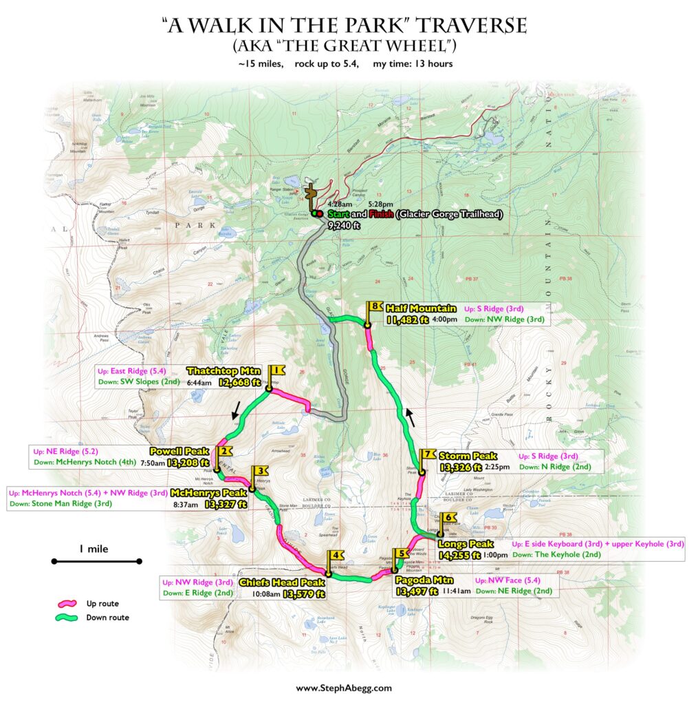
A Walk in the Park Traverse (aka The Great Wheel) (~15 miles, rock up to 5.4, 13 hours car to car): Thatchtop, Powell, McHenrys, Chiefs Head, Pagoda, Longs, Storm, Half

"A Walk in the Park" Traverse (aka "The Great Wheel")

Routes:

~15 miles, rock up to 5.4, 13 hours car to car

- Thatchtop Mountain (12,668')
- Powell Peak (13,208')
- McHenrys Peak (13,327')
- Chiefs Head Peak (13,579')
- Pagoda Mountain (13,497')
- Longs Peak (14,255')
- Storm Peak (13,326')
- Half Mountain (11,482')

A round tour traverse of 8 summits along the entire rim of Glacier Gorge.

Region: Colorado
Elev: 11,482-14,255 ft
Rock type: Gneiss, Biotite schist, Granite
Type: 
Date(s): July 7, 2020 (Tue)
Partner(s): solo

Labeled Panoramas

CLICK TO ENLARGE

Map & Google Earth

CLICK TO ENLARGE

Intro

"A Walk in the Park" spans the entire rim of Glacier Gorge, traversing the eight summits in fifteen miles. It is an athletic circuit with several route-finding challenges and occasional sections of low-5th class climbing. It was originally named "The Great Wheel", but this had only been done in pieces, and after Richard Rossiter completed the entire circuit in a single push in 2009, he renamed it "A Walk in the Park" in his published guidebook.

I did this traverse solo, wearing only approach shoes and carrying a light daypack with an extra layer, a headlight, my phone, some food and water, and my camera. I never stopped for more than a few minutes, maintaining steady travel at a relatively relaxed pace, taking lots of photos as I went. I had no real route-finding issues, although I spent a bit of time on Pagoda finding a 5.4 route on the NW side that I was comfortable with. The entire traverse from Glacier Gorge Trailhead and back again took me exactly 13 hours, to the minute. This was also the car-to-car time achieved by Richard Rossiter in 2009. I know people have done the traverse significantly faster (check out mountainproject comments for some fast car-to-car times), and I feel I could probably shave a few hours off of my time if I wanted to go for speed, but I am was in no real hurry and my only real goal was to enjoy a nice day out in the park.

(One of the reasons I did this traverse was to scope out the section from Powell to Longs, for an amazing 50 mile traverse of the entire Estes Park skyline from Mummy to Meeker, which my climbing partner Nate and I successfully executed the following week. Click the link for a trip report for this "Estes Skyline High Route".)

(Note also that I did not follow the exact route described in Rossiter's guidebook. I made three route variations. (1) Rossiter describes ascending the Regular Route (2nd) on Thatchtop, while I ascended the East Ridge (5.4) because I'd never seen Shelf and Solitude Lakes and wanted to visit them on the way. (2&3) Rossiter describes ascending the Southwest Ridge (5.5) of Longs and desceding the Keyhole Ridge (5.5-5.6), while I ascended and descended the Keyhole Route (3rd) because I had never climbed either route and was wary about soloing the mid-5th class terrain. Someday I plan to do the Walk in the Park again and take the route described by Rossiter. Plus, the ways he describs are more direct and likely faster than the ways I took.)

The following page gives a map, google earth overlay, route summary, stats, and photos from the day. What a wonderful walk in the park!

Time Stats

Note: I also recorded my time splits on the Estes Skyline High Route, which includes the portion from Powell to Longs. These time splits are given in blue below.

A Walk in the Park, Peak by Peak

THIS TRIP REPORT IS STILL MOSTLY IN THE EMBEDDED HTML FORMAT OF MY OLD WEBSITE.

The rest of this page contains photos from the traverse, broken down into the sections pertaining to each of the eight summits. Enjoy!

CLICK ON PEAK SECTION TO DROP DOWN CONTENT

#1: Thatchtop Mountain   (Glacier Gorge Trailhead (4:28am) --> Base of East Ridge of Thatchtop --> Thatchtop Summit (6:44am))
STATS: 2:16 from trailhead to summit; 17.4% of total travel time; 17.4% completed with traverse on summit 
Photos:
1.    
2.    
3.    
4.    
5.    
6.    
7.    
8.    
9.    
10.    


Photo descriptions:
1. Pack weight = 7 lbs 1 oz.
2. To get to the East Ridge of Thatchtop, I approached via a steep path leading to Solitude and Shelf Lakes. This path ascends a gully between the hillside and Arrowhead in the photo.
3. Just a photo taken along the path up to Solitude and Shelf Lakes.
4. Shelf Lake and the north side of Arrowhead.
5. I watched this snow slope collapse into the lake. That was fun.
6. Morning sun. The small peak silhouetted on the left is Half Mountain, the end of the Traverse.
7. The East Ridge of Thatchtop ascends this.
8. This is the way I went. It seemed easier than 5.4 to me.
9. The upper slopes on the 
East Ridge of Thatchtop. 
10. Some pretty columbine.

#2: Powell Peak   (Thatchtop Summit --> Thatchtop-Powell saddle --> Powell Summit (7:50am))
STATS: 1:06 from previous summit; 8.5% of total travel time; 25.9% completed with traverse on summit 
Photos:
1.    
2.    
3.    
4.    
5.     
Photo descriptions:
1. Looking towards Powell from the summit of Thatchtop. Point 12,836 is in the foreground as must be traversed over to get to Powell's Northeast Ridge.
2. This photo was taken as I traversed over Point 12,836. Now you can see the Northeast Ridge of Powell.
3. The 5.2 Northeast Ridge of Powell.
4. A view of McHenry's Notch. I would have to traverse through the notch to get from Powell to McHenrys.
5. I had the topo map of RMNP downloaded to my phone. On each summit took a timestamp photo.

#3: McHenrys Peak   (Powell Summit --> McHenrys Notch --> McHenrys Summit (8:37am))
STATS: 0:47 from previous summit; 6.0% of total travel time; 31.9% completed with traverse on summit  
Photos:
1.    
2.    
3.    
4.    
5.     
Photo descriptions:
1. Looking towards McHenrys from the summit of Powell. The chasm between Powell and McHenrys is McHenrys Notch. This was a big unknown of the Traverse, but it ended up being pretty chill.
2. A grassy 3rd class ramp on the southwest side of a tower that used to get from Powell to McHenrys Notch. 
3. McHenrys Notch.
4. The 5.4 exit from the Notch to get to the summit of McHenrys. The rock was featured and this ended up feeling pretty mellow.
5. Summit cairn on McHenrys.

#4: Chiefs Head Peak  (McHenrys Summit --> McHenrys-Chiefs Head Saddle --> Chiefs Head Summit (10:08am))
STATS: 1:31 from previous summit; 11.7% of total travel time; 43.6% completed with traverse on summit 
Photos:
1.    
2.    
3.    
4.    
5.    
6.      
Photo descriptions:
1. The long ridge from McHenrys to Chiefs Head. I stayed just right of the ridge for the most part. It was all 3rd class but it was a lot of terrain and took about a hour and a half to get from summit to summit.
2. Stoneman Tower and Stoneman Pass.
3. I went around these towers on the right.
4. The mellow slopes up to the summit of Chiefs Head.
5. Some pretty sky pilot flowers.
6. I met three hiker/runners on the summit of Chiefs Head. They had ascended from Wild Basin. These were the only people I ran into on the traverse except for when I briefly intersected the Keyhole Route on Longs Peak.

#5: Pagoda Mountain  (Chiefs Head Summit --> Chiefs Head-Pagoda Saddle --> Pagoda Summit (11:41am))
STATS: 1:33 from previous summit; 11.9% of total travel time; 55.5% completed with traverse on summit

July 2024 Update: I did the West Ridge Bypass (low 5th) on Pagoda. This is the way I would recommend rather than the NW Face that I did for the trip report on this page. Click link to see the trip report for West Ridge Bypass (low 5th).
Photos:
1.    
2.    
3.    
4.    
5.    
6.    
7.      
Photo descriptions:
1. Looking towards Pagoda and Longs from Chiefs Head.
2. The West Ridge of Pagoda. This is 5.7. I went left to get onto the NW Face route which is 5.4.
3. The route line in the guidebook went across this face. It was sort of slabby with a giant cliff below so I didn't feel comfortable crossing it.
4. Instead I ascended this crack system.
5. I cut across here and headed up towards the West Ridge.
6. Easier terrain heading up to the upper West Ridge.
7. Summit register on Pagoda.

#6: Longs Peak   (Pagoda Summit --> Pagoda-Longs Saddle --> Longs Summit (1:00pm))
STATS: 1:19 from previous summit; 10.1% of total travel time; 65.6% completed with traverse on summit 
Photos:
1.    
2.    
3.    
4.    
5.    
6.    
7.    
8.   
Photo descriptions:
1. Looking towards Longs Peak from Pagoda. I traversed across the talus slope and through the weakness in the cliff band, and then continued up until I intersected the Keyhole Route and took that to the summit.
2. I found some water below a snow patch between Pagoda and Longs. This was good since I had run out of water on McHenrys. Water is hard to find on the ridge.
3. The weakness in the cliff band. It was 3rd class.
4. The rocky slopes below The Keyhole Route. I climbed up a steep cliffband that felt like 5.6 for about 20 feet, but I could have avoided this by scrambling up a 3rd class gully further to the right.
5. The Homestretch to the summit.
6. A painted marker on The Keyhole Route.
7. On the summit. There was a small squall brewing on the horizon that ended up blowing through about 20 minutes after I took this photo, but it was short.
8. Summit.

#7: Storm Peak   (Longs Summit --> Longs-Storm Saddle --> Storm Peak Summit (2:25pm))
STATS: 1:25 from previous summit; 10.9% of total travel time; 76.5% completed with traverse on summit 
Photos:
1.    
2.     
Photo descriptions:
1. Hiking along The Narrows section of The Keyhole route on the descent of Longs Peak.
2. Nearing the summit of Storm Peak.

#8: Half Mountain  (Storm Peak Summit --> Storm-Half Saddle --> Half Mtn Summit (4:00pm))
STATS: 1:35 from previous summit; 12.2% of total travel time; 88.7% completed with traverse on summit 
Photos:
1.    
2.    
3.    
4.    
5.    
6.    
7.    
8.    
9.    
10.   
Photo descriptions:
1. A view towards Half Mountain from near the top of Storm Peak. Half Mountain is at the end of the ridge. 
2. Moss campion.
3. Some pretty yellow flowers.
4. This was a kind of cool cloud.
5. View back towards Longs Peak.
6. Midway along the ridge from Storm Peak to Half Mountain. That's Mill Lake below.
7. Some steep cliffs of Astro Tower. There are some climbs on this. Someday I want to check them out.
8. Steep cliffs near Half Mountain.
9. A gnarled snag near the summit of Half Mountain.
10. Summit register on Half Mountain.

Trailhead  (Half Mtn Summit --> Trail --> Glacier Gorge Trailhead (5:28pm))
STATS: 1:28 from previous summit; 11.3% of total travel time; 100% completed with traverse at trailhead
Photos:
1.    
2.    
3.  
Photo descriptions:
1. Talus slopes leading back down to Mills Lake.
2. Stonecrop.
3. Back at the Glacier Gorge Trailhead, exactly 13 hours car-to-car.

Comments Pertaining to this Page / Trip Report

Useful beta. Updated route information. Corrections. Historical notes. Interesting facts. No fluff please.
Leave a Reply

Your email address will not be published. Required fields are marked *