The original plan was to climb the NE buttress of Mt. Goode, but when the forecast didn't look Goode, Aaron and I tossed about some ideas for a worthy alternative climbing objective. Weather still looked decent further north. How about the impressive north buttress of Bear Mountain? The 2000-ft steep north face of Bear has some of the best and most intimidating alpine rock climbing in the Cascades. Better yet, getting there requires a passport and a strenuous bushwhack.
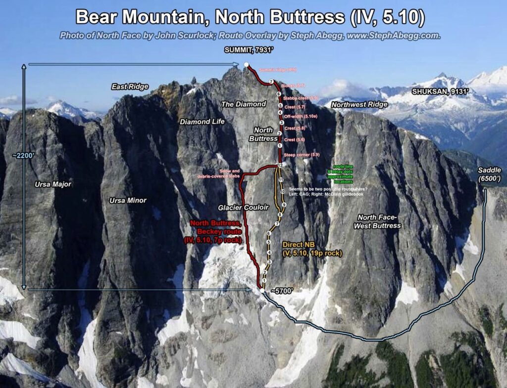
The north side of Bear has several difficult routes. The north buttress was our destination. The classic climbing on the steep upper buttress can be gained in 2 ways: (1) via Beckey and Fielding's 1967 route up a glacier couloir, referred to as the "North Face Buttress" in CAG or "North Face" route in Alpine Select or (2) via Kearney and Knight's 1980 direct start which climbs seven difficult (5.10) pitches on the lower buttress, referred to as "Direct North Buttress" in both CAG and Alpine Select. (An interesting tidbit of history: The North Buttress was Beckey's last big project in the North Cascades. And Mark Fielding was AWOL from the ARMY at the time of the first ascent; he turned himself in after completing this climb.)
Our initial goal was to climb the buttress via the direct route, but after some discussion at camp the night before the climb, we decided to use Beckey and Fielding's route to the upper buttress so that we could enjoy these stellar pitches without being pressed for time or tired out by the lower pitches. However, as we ascended the glacier couloir the next day, dodging falling rocks and traversing exposed pebble-strewn slabs, we looked longingly at the lower buttress, wishing we had not left our big cams back at basecamp. In retrospect, our decision to climb the quicker couloir was fortunate, as it began to rain just as we finished our climb and the rock became surprisingly slippery - we would not have wanted to climb the last few pitches of the upper buttress (particularly the slabby 5.9 pitch) in these conditions.
I will be back someday to climb the DNB!
Aaron and I had a great time on this climb. It was the first time I had climbed with Aaron, and I hope we can get together for some more climbing in the future. The climbing was some of the best I've encountered in Cascades alpine terrain. I think both of us are inspired to return some day to climb the direct route. We joked that if I made my trip report really good, then perhaps enough people would go climb Bear and trample down a nice path through the grueling bushwhacky approach!
Below is a pitch-by-pitch description (with photos of each pitch) of the amazing North Buttress of Bear Mtn.
Approach
~9 miles, 4500' up, 9 hours
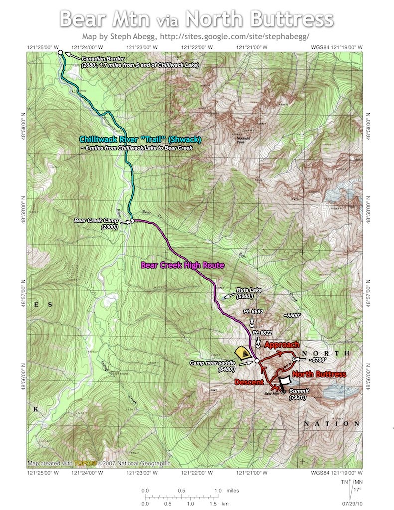
The trailhead is at the end of the Chilliwack Lake Road (accessed off HWY 1 east of Vancouver, BC). There is a gate and bridge here.
Walk the final 1.5 miles of road to the south end of Chilliwack Lake and get on the Chilliwack River Trail. The trail is pretty good and well-flagged until it crosses the US border at around 1.7 miles. Then it becomes quite overgrown (hasn't been maintained since the 70's probably), and is at times nearly impossible to find. We often found ourselves shwacking through some pretty dense thickets. It took us 5 hours to get to Bear Creek, about 6 miles from the trailhead.
Just after crossing Bear Creek, ascend steep timber eastward. At the treeline climb through huckleberry bushes before coming to the meadowland above Ruta Lake. It took us 2.5 hours to get here. Continue along the divide, then traverse the south slopes around Points 6592 and 6822, crossing a rock rib to a saddle (6480'). There is nice camping in this area. It took us 9 hours to get to here from the car. This approach definitely rivals any approach into the Picket Range.
North Buttress Pitch-by-Pitch
IV, 5.10, 2200' up, 7 roped pitches (5.7-5.10), 10.5 hours camp-to-camp
Camp to base of route:
<1 mile, 1000’ loss, ~250' gain, 1.5 hours
Descend snow/talus NE from the 6840' saddle to get below the North Face buttress at about 5500'. Traverse talus/snow to the base of the glacier couloir just left of the North Buttress (~5700').
Glacier couloir: ~1100' gain, 3.5 hours
Climb snow and debris-covered 4th class slabs up the glacier couloir, eventually getting onto a 3rd class ramp that leads to the buttress crest. We found this area to be very loose and unprotectable, and had several close calls with falling rocks. We regretted our decision not to climb the cleaner (albeit harder) direct north buttress! (Although, in retrospect, given the rain that moved in just as we reached the summit, it was overall a good thing we took the quicker approach up the glacier couloir.)
Upper Buttress, Pitch 1: 5.9, 150'
Steep corner just left of crest. This was superb climbing. Perhaps it was our heavy packs, but Aaron and I felt this pitch deserves a nice little "+" tacked onto the rating.
Upper Buttress, Pitch 2: 5.6, 120'
Fun climbing on the crest.
Upper Buttress, Pitch 3: 5.8, 120'
Steep rock left of crest (5.8) to a nice ledge below an off-width crack (1967 party bivied on this ledge).
Upper Buttress, Pitch 4: 5.10a, 120'
Off-width crack with nice positive crimpy holds. This was not as bad as we thought it would be with our packs on, and we actually found it easier than the first pitch. (An alternative to the off-width is to go right along the buttress crest on exposed 5.8.)
Upper Buttress, Pitch 5: 5.7, 120'
Blocks and cracks on the crest to below a steep step.
Upper Buttress, Pitch 6: 5.9, 150'
Airy face climbing on the crest to a set of twin cracks. The exposure on this pitch is exhilarating, but the holds are perfectly positioned. (An alternative is to down climb and tension-traverse down and right into a 4th class chimney that leads back to the crest above the step, but this looked kind of tricky.)
Upper Buttress, Pitch 7: 5.7, 150'
Blocky climbing to the top of the buttress. From here, it is a scramble to the summit.
To Summit: 4th, 200', 4.5 hours from glacier couloir
From the top of the north buttress, it is a short blocky scramble to the summit. It had started to rain, and the rock was a bit slippery, so we opted to simulclimb instead of solo. It took us 4.5 hours to climb the upper buttress to the summit. This summit doesn't see much traffic, but we discovered that 3 parties had signed the summit register since 2006.
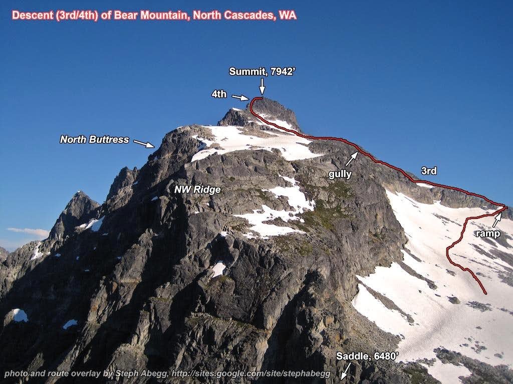
Descent: 3rd/4th, 1 hour
The descent is direct and straightforward, and took us about 1 hour. From
the summit, descend westward, keeping on the south side of the ridge. Stay left until able to down-climb a short 3rd class rock gully leading
north and back to camp.


