Evergreen Mountain / Fire Lookout, Southwest Ridge (snowshoe)

Evergreen Mountain / Fire Lookout

Route:

SW Ridge

snowshoe

It's always fun to turn an easy summer dayhike into a snowy adventure. And yet one more lookout closer to my goal to visit all 92 standing fire lookouts in WA.

Region: Washington
Elev: 5,587 ft
Type: 
Date(s): November 19, 2011 (Sat)
Partner(s): Justin Cox, Gabriel Deal, Natala Goodman, Mike Helminger, Matt Reisenauer, Brian Walkenhauer

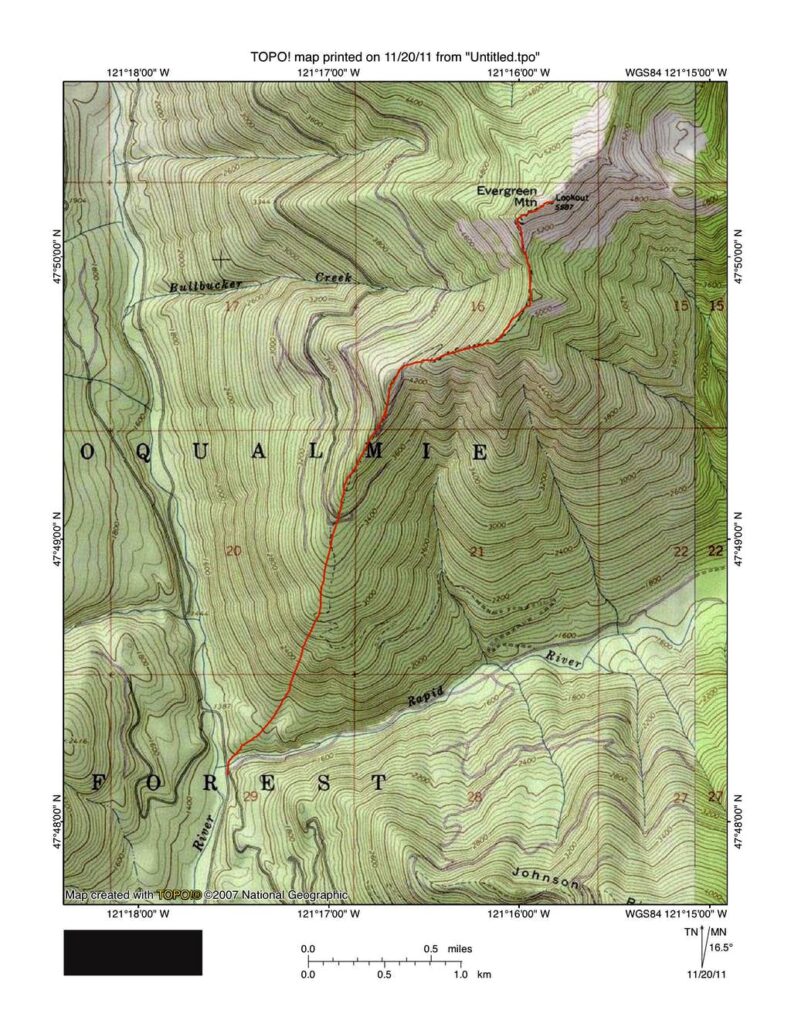
Map

CLICK TO ENLARGE

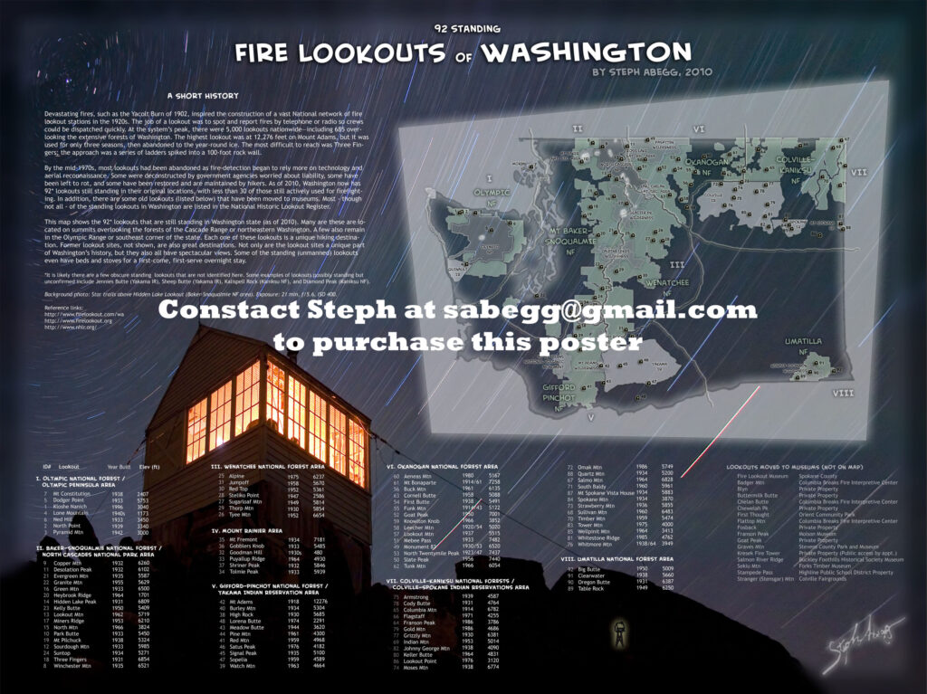
Fire Lookouts of Washington

While I lived in Washington, I tried to visit as many of the remaining standing fire lookouts scattered about the mountain ranges of Washington as I could. Click the following link to go to my webpage on fire lookout structures of Washington, which gives a bit of history of fire lookouts as well as a complete listing of the remaining standing lookout structures in the state.

CLICK TO ENLARGE

Trip Report

THIS TRIP REPORT IS STILL MOSTLY IN THE EMBEDDED HTML FORMAT OF MY OLD WEBSITE.

L to R: Justin, Mike, Natala, Brian, Gabriel, Matt, me (behind camera, click link).

Route Info

It's always fun to make an easy summer dayhike into a snowy adventure. Evergreen Mountain is a good route for that. There's even a snow-encased lookout. Plus, the 5,587-foot summit offers alpine views in every direction. Dominating the scene are Glacier Peak, Mt. Daniels, Columbia Glacier, Kyes Peak, and Henry M. Jackson Wilderness.

In the summer the hike is short but steep (1412' and 1.5 miles to summit). Driving directions: From Everett head east on US 2 for 49 miles to the small town of Skykomish. Continue east for 1 more mile, turning left onto Beckler River Road (Forest Road 65). The pavement ends at 6.9 miles. Continue north for another 5.7 miles to a five-way junction at Jack Pass. Take the road to your immediate right (FR 6550) for 0.9 mile to a junction. Turn left onto FR 6554 and drive 8.7 scenic miles to its end at the trailhead (elevation 4175'). 

In the winter when snow blocks off the higher sections of road, it is typical to park just after the pavement ends on the Beckler River Road, at the turnoff for Rapid River Road (elevation 1375'). Just tackle the timbered ridge of Evergreen Mountain straight up from here. This makes it 4212' and 4.35 miles to summit, or 8.7 miles round trip. We encountered  snow right from the beginning, and about 1/3 of the way up it became deep enough to put on snowshoes. With a recent dump of a few feet of fresh snow making avalanche conditions a consideration, Evergreen Mountain was a good choice since the route mostly maintains a timbered ridge and does not involve crossing any major slopes.

Despite the forecast calling for clouds and 50% chance of snow, it turned out to be a beautiful sunny day with just enough cloud cover to make photography more interesting and give rise to some unique halos and sundog formations (the 46° halo that shows in one of the photographs below is quite rare, according to my favorite atmospheric optics website). And the fresh snow was pristine and powdery. It took us 4h20 min to arrive at the lookout on the summit (the lookout was unfortunately locked), and after a quick lunch which inspired us to get moving again, it took us 2h30 min to descend to the cars. A fun day in the mountains!

(This trip was another recovery milestone, one of my first real "climbs" since nearly loosing my leg the previous September in a climbing accident. It's nice to start getting out in the mountains again!)

Photos
Here is a selection of my favorite photos from the day.

(I apologize for the at least five typos in the photo captions that have been pointed out to me. When I wrote the captions, I had been awake about 24 hours—8 of which involved climbing a mountain and 6 of which involved driving between home and the trailhead. Lesson learned: save the caption writing for the next day. Or start drinking coffee again.)


The Lookout
The Evergreen Mountain Lookout has a somewhat colorful history. One of several lookouts built by the Forest Service during the 20's and 30's, Evergreen Mountain Lookout was built in 1935 for detecting wildfires in the Skykomish drainage. During World War II, it was used as an Aircraft Warning Station. The last big fire spotted on Evergreen Mountain, the Evergreen Fire in 1967, was inadvertently set by loggers during a timber operation on the south side of the mountain and burned the rocky south face of the ridge to within several hundred feet of the lookout. Evergreen Mountain Lookout remained active until the early 1980s. In 1990 a local volunteer group adopted Evergreen Mountain Lookout and began restoration efforts. During restoration it was placed on the National Register of Historic Places and nominated for the National Historic Lookout Register.

Evergreen Mountain Lookout is available for rental ($40 per night per group) by reservations only from August 1st through October 15th. All other times of year it is locked against access. The 14 x 14 foot lookout is comfortably furnished with one twin-sized bed and mattress, 3 extra mattresses, table, step stool, 6 folding chairs, twin burner propane stove, and 2 twin mantle propane lanterns. Sunrise and sunset are bound to be spectacular from this lofty perch. 

Comments Pertaining to this Page / Trip Report

Useful beta. Updated route information. Corrections. Historical notes. Interesting facts. No fluff please.
Leave a Reply

Your email address will not be published. Required fields are marked *