|
Route Notes:
We began the trip with grand plans to climb McGregor Mtn car-to-car from Rainy Pass in a day, but when 4am found us wandering in an already soft layer of snow covering the PCT and low clouds overhead threatening rain, we concluded that our valuable Sunday would be better spent elsewhere. A frenzy of front-seat powwowing, and we were headed 1.5 hours east towards Twisp River Road. The plan was Bugger Mountain, one of the Top 200 peaks Tom has been methodically checking off of his list. Better yet, neither of us had climbed it.
(As detailed in the "Naming Notes" section on this page below, Bugger Mountain is also known as "Mt. Gibbs" or "Grandfather" or "Ba Peak". But I use Bugger in this TR since it was one bugger of a
climb to get up there.)
One factor that would prove to influence the day was the fact that we did not have a map for our new summit destination. Tom had an atlas, but its 100 m (330 ft) contours, lack of label for Bugger Mountain, and 2-lb leave-it-in-the-car weight didn't help us much when it came to route-finding. It was inevitable this would have an interesting effect on the day.
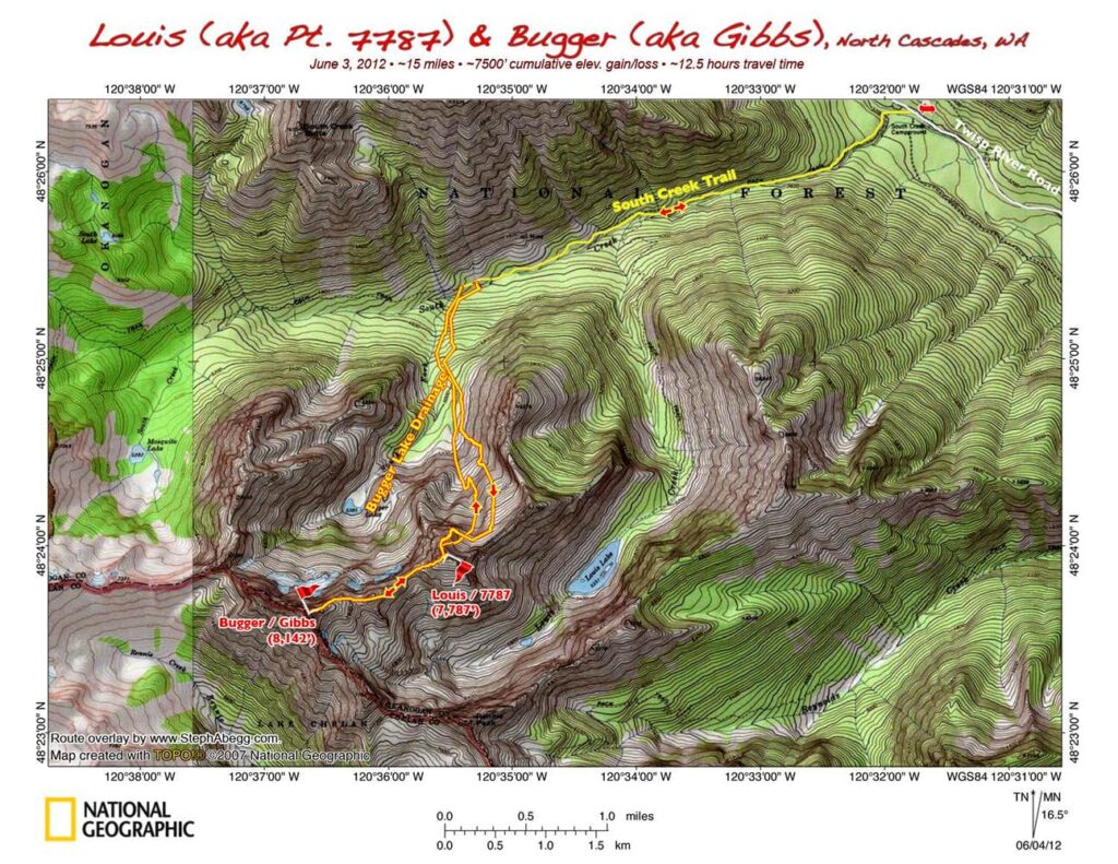
Mapless, we were hiking up the South Creek trail off of the Twisp River Road by 6am. After 3.3 miles, we concluded we were at the Bugger Lake drainage, and we left the trail and headed south. The first crux of the climb was crossing South Creek, which was "definitely not wadeable" in its rushing spring flow. Finally we found a nice big log and scooted across.
We hit snow on the other side of the creek and put on snowshoes. Then the snow strangely disappeared as we ascended, and we stubbornly "dry-shoed" for a good 20 minutes before resigning ourselves to the fact that snowshoes weren't designed for dirt and alder thickets. We would not put the snowshoes on for the remainder of the trip, as the snow was consolidated or steep enough that they were not needed. Whether or not the snowshoes were worth carrying all the way for the uniqueness of the dry-shoeing experience remains inconclusive.
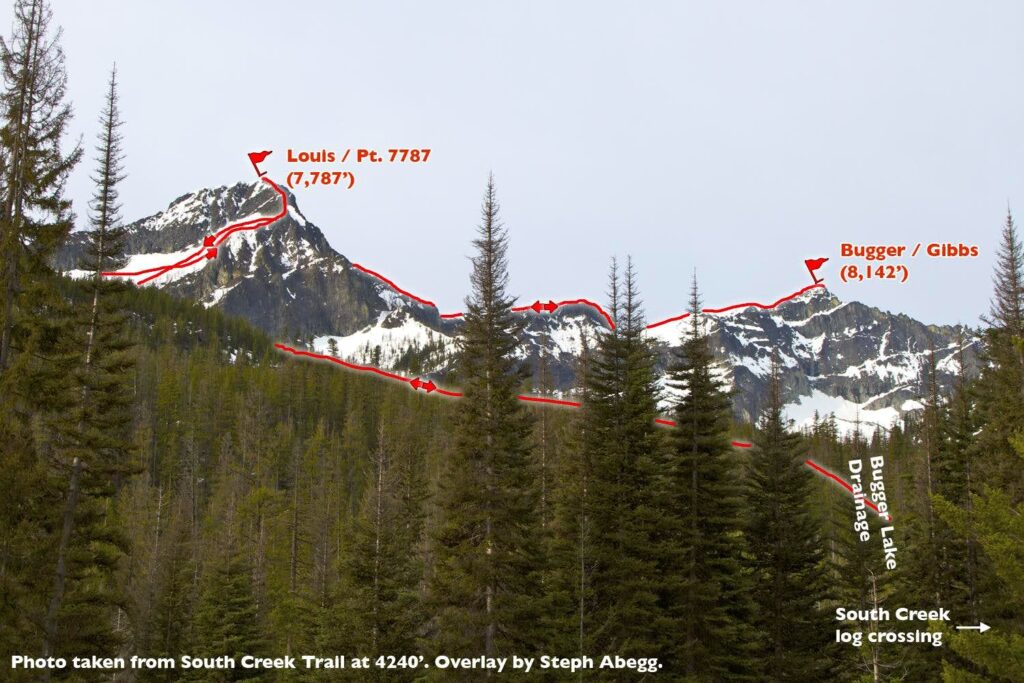
Eventually, we found ourselves in a north-facing snowbowl below a hulking summit. As a side note, we saw some kind of cute weasel in the rocks, but it was gone by the time I pulled out my camera. We had initially planned on heading up the ridge on the left (east) skyline, but when it became evident that this ridge was only a subsidiary ridge with a cornice issue at the top, we reconsidered and decided to head across the snowbowl to a north ridge on the right skyline.
Perhaps if we had had a map, we would have seen that we could have wrapped around the east side to the mellow south slopes. Or, more importantly, we would have discovered this wasn't even Bugger Mountain.
But we didn't have a map, so up we headed up the north ridge of this misidentified mountain. The terrain started off pretty easy in steep boot-step snow slopes leading to fun 3rd class ridge scrambling. Then, about 400 ft below the summit, things started to get sketchy. The ridge got steeper. The rock got looser. The black lichen got thicker. But we continued up, testing every rock and moving slowly. It never exceeded 4th class, but there was no room for error.
Eventually we did reach the summit. We found a register in an old pill bottle. The last climb of "Louis Peak / Pt 7787" (we now realized our mistake) had been a year ago, and it was not climbed often. We figured there was a high probability we had just made a first ascent of what we were now calling Rotten Molar Ridge. Rotten Molar Ridge will not likely soon become a popular ascent route.
I had decided to leave my pack about 100ft below the summit, due to balance issues I have with a heavy camera-gear-laden pack on tedious terrain. If I had known we would be continuing on to climb another summit, I would have at least stuffed my pockets with snacks or taken off the top of my pack and brought my camera, water, and Billy along. As it was, Billy would be lonely for a few hours. And Tom would soon be without a camera as I found myself unable to function without one.
From the top of Louis/7787, we spotted what we (correctly) surmised was the true Bugger Mountain to the west. It looked like a fairly easy ramble across rock and snow. It took us 1.5 hours to get to the summit. The summit register stated that this was "Mt. Gibbs" (fortunately, we were aware of this alternative name for Bugger, so we knew now we were on our intended summit). The register for Bugger/Gibbs was as sparse as the one on Louis; I guess these summits aren't popular climbing destinations, overshadowed by Reynolds Peak just to the south. We spent a few moments surveying the views and identifying summits (we had clouds and even a little snow at times, but the clouds were high enough that we still could see mountains around us). Then we reversed the route back to Louis.
We might have tried to descend from Bugger and Louis via a different (and safer) route than Rotten Molar Ridge, but I had to collect my pack on the way down and we did not have a map to help us choose a better descent route. A map would have revealed an easy glissade southward into the Louis Creek drainage, from where there was a trail out to the main trail (in fact, according to the Cascade Alpine Guide route description I read after the trip, this drainage is the favored ascent route for Bugger/Gibbs). But sometimes not having a map just adds to the adventure, sort of like discovering the area like the original explorers did.
In any case, we made it back to the car in a little shorter time than it took us to ascend. My gps later indicated we had traveled 15 miles and gained/lost about 7500' over the course of the 12 hours and 40 minutes we had been away from the car. Due to the terrain, it had been a pretty rigorous 15 miles.
All in all, another full and fun adventure, and a likely first ascent of Louis' Rotten Molar Ridge to boot! Worth the 4 hours of driving we now had to endure in order to get home....
Naming Notes (info courtesy of John Roper):
When we climbed Bugger, I was already familiar with its alternative name as "Mt. Gibbs." It turns out there are actually a whopping four names associated with this rather unknown summit!
- "Bugger Mountain" - The name 'Bugger' comes from Bugger Lake in S Fork South Creek basin. Lixvar put the Bugger name here on his 1976 Top 194/200 list moving the name of the lake to the top of the mountain. According to wikipedia, 'Bugger' is a slag word originally with sexual connotations, but today a general-purpose expletive used to imply dissatisfaction.
- "Mt. Gibbs" - This was Fred Beckey's name for the summit, named after George Gibbs, an early explorer and geologist. George is certainly worthy of having his name on a WA peak, but I am not sure this is the right area for it.
- "Grandfather" - Stephen Fry came up with this name when he was putting together the T100xP1000 list (a list that is begging for a second completion now 21 years later).
- "Ba Peak" - This follows along in the grandfather theme. According to peak-naming aficionado John Roper, 'Ba' comes from the name his son Aaron bestowed to his grandfather when he was first learning to talk. This is the name given to the summit on Google Earth.
As for me, I will remember Bugger/Gibbs/Grandfather/Ba as Bugger Mountain, since it was one bugger of a climb to get up there.
Stats:
Roundtrip distance: ~15 miles (according to my GPS)
Elevation gain/loss: ~7,500 ft cumulative for entire trip
TH to Louis: 5:20; Louis to Bugger: 1:30; Bugger to Louis: 1:00; Louis to TH: 4:30; Total travel time: 12:40
- 9:00 pm (Sat): Drive to WA Pass area, camp
- 3:00 am (Sun): Wake up, decide to head east to find better weather
- 5:04 am: Sunrise
- 5:58 am; 0 mi; 3,200 ft: Arrive at South Creek Trailhead on Twisp River Road
- 6:07 am; 0 mi; 3,200 ft: Start hiking
- 7:18 am; ~3.3 mi; 4,240 ft: Turn off trail into Bugger Lake drainage
- 8:18 am; ~4 mi; 4,800 ft: Hit continuous snow
- 11:27 am; ~6.5 mi; 7,787 ft: Louis Peak summit
- 1:12 pm; ~7.5 mi; 8,142 ft: Bugger Mtn summit
- 2:17 pm; ~8.5 mi; 7,787 ft: Louis Peak summit, start descent
- 6:47 pm: ~15 mi; 3,200 ft: Arrive back at car
- 8:58 pm: Sunset
|
|


