Cirque of the Towers July 2014: Overhanging Tower Northeast Ridge, Pingora South Buttress K-Cracks variation, Mitchell North Face Left, Shark’s Nose The Thoroughfare, Pingora East Face Left, Sundance Pinnacle East Face Center
Cirque of the Towers July 2014
Routes:
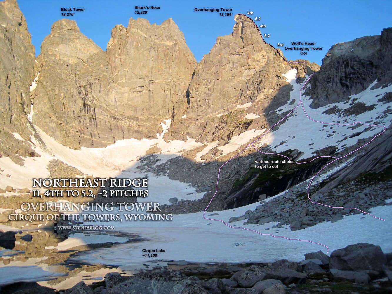
- Overhanging Tower, NE Ridge (4th to 5.2, ~2p)
- Pingora, South Buttress K-cracks variation (5.8, 4p)
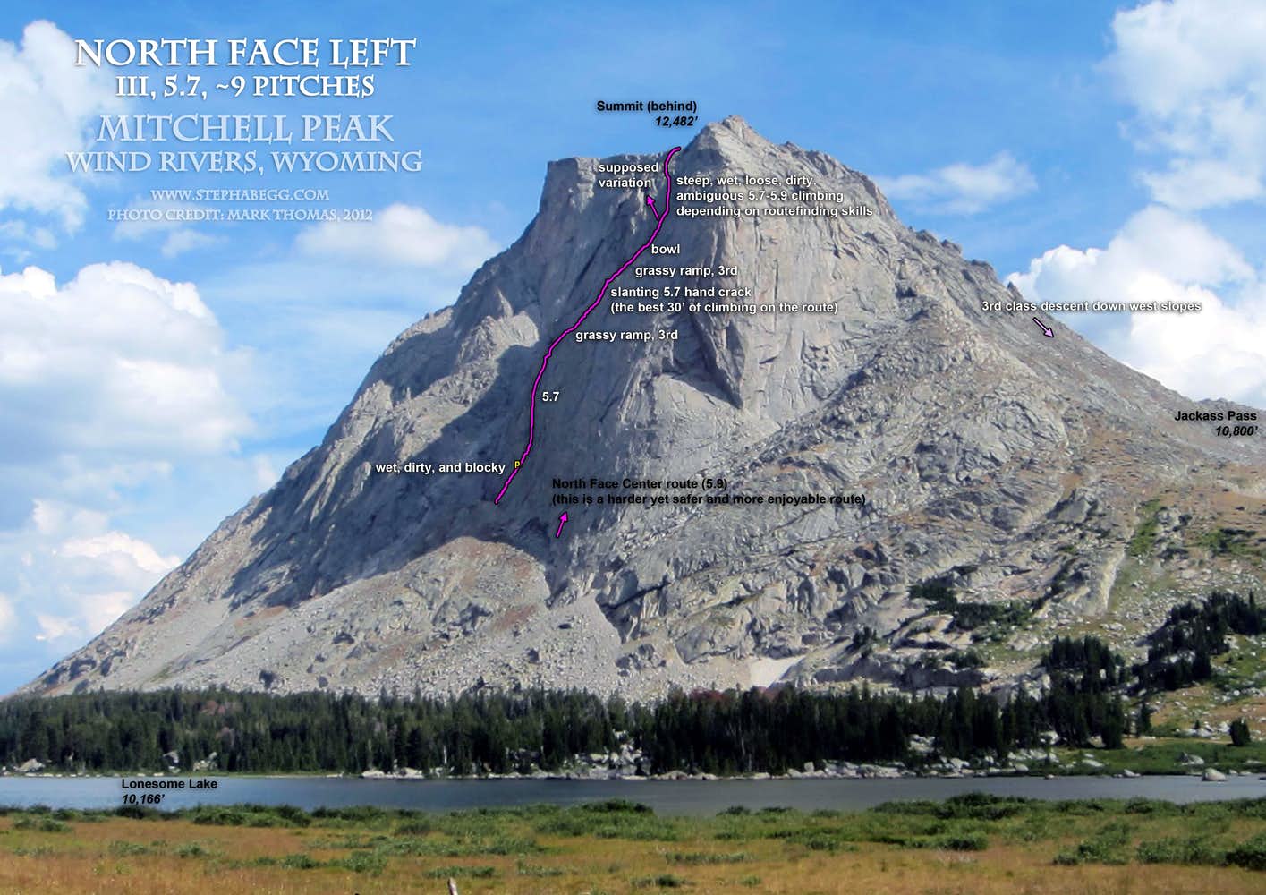
- Mt. Mitchell, North Face Left (5.7, ~9p)
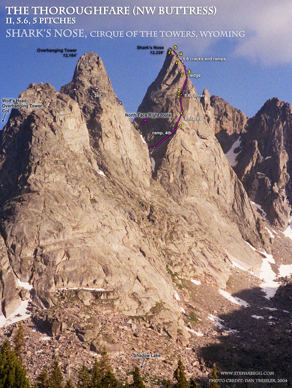
- Shark's Nose, The Thoroughfare (aka NW Buttress) (5.6, 5p)
- Pingora, East Face Left (5.7, ~10p)
- Sundance Pinnacle, East Face Center (5.9, 3p)
You know it's a great climbing area when you don't climb a single route you planned on and it's still a great climbing trip.
Region: Wyoming
Elev: 11,000-12,500 ft
Rock: Granite
Mode:
Date(s): July 17-24, 2014 (Thu-Thu)
Partner(s): Scott Smith (Climbs 1-3) / Eric Gottlieb and Brian Hart (Climb 4) / Eric Gottlieb (Climb 5) / Bill Grantham and Clair Wilcox (Climb 6)
THIS TRIP REPORT IS STILL MOSTLY IN THE EMBEDDED HTML FORMAT OF MY OLD WEBSITE. MOBILE Tip: Try Landscape mode. It is generally more mobile friendly.
When it comes to alpine cragging, the Cirque of the Towers is hard to beat. In fact, the Cirque is the location of my first rock climb: the Northeast Face of Overhanging Tower, a mostly 4th class adventure (with a couple of 5.2 moves) on the short ridgeline rising up from the Wolf's Head-Overhanging Tower Col. I was only 11 years old. I remember my dad even let me "lead" a bit, which I'm sure amounted to me just climbing within arms reach directly above him. By the time I got to the summit, I knew I wanted to do more of this fun activity called rock climbing.
1994 trip:
Approaching the trailhead in our faithful Dodge Caravan.
At the Big Sandy trailhead. We were joined by family friends Matt (left) and Sheryl center) (my mom is taking the photo).
Me, my dad, and Matt the summit of Overhanging Tower.
I first returned to the Cirque in 2007 to climb the two classic routes with my cousin: the NE Face of Pingora and the East Ridge of Wolf's Head. But these are only two of many great climbs in the Cirque, so I knew I would be back again. July 2014 marked the 20 year anniversary of my first climb, so it was as good a time as any to plan another trip to the Cirque.
Earlier in July while climbing Elephant's Perch, I proposed the idea to my partner Scott. He had never been to the Cirque, and was excited to plan a trip. We hashed out a short list of routes we wanted to do (Wolf's Head Beckey Route, Shark's Nose North Face, Pingora Southwest Face, Mitchell North Face Center, Warrior Northeast Face) and made plans to be in the Cirque for eight days; accounting for the hike in and hike out, this would give us six full days of climbing, weather permitting.
The following page gives a trip report for this eight day adventure to the Cirque. Somehow we managed to not climb a single route on our tick list, yet it still turned out to be a great trip. I climbed six routes in six days—three routes with Scott and three routes with some climbers (Eric, Brian, Bill, and Claire) I met in the Cirque who were part of a large group of friends from Albuquerque.
(Update: I returned to the Cirque in August (of the same year) to climb some harder routes. This was a phenomenal trip. I also returned in July 2019 to do the awesome Cirque Traverse, which included three of the routes detailed in the trip report on this page: the NE Ridge of Overhanging Tower, the South Buttress of Pingora, and The Thoroughfare on Shark's Nose)
Climbs We Did
CLICK ON ROUTE TO DROP DOWN CONTENT
Hike about 9 miles from Big Sandy Opening to the Cirque via Arrowhead Lake / Jackass Pass.
Photos:
a.
b.
c.
d.
e.
f.
g.
h.
i.
j.
k.
l.
m.
n.
o.
Photo descriptions:
a. On the road to the Big Sandy Trailhead. It takes about 2 hours to drive to the trailhead from Pinedale.
b. The crux of the hike in was the 100-200 foot stretch of boulders alongside Arrowhead Lake just before entering the Cirque. Our packs were onerously heavy with 8 days worth of food and enough climbing gear to supply our ambitious climbing plans. Add to that my SLR and extra batteries and remote and tripod for night photography, and my pack weighed nearly 80 lbs!
c. Our first glimpse of Wolf's Head and Pingora as we hiked on the climbers trail along the west side of Arrowhead Lake.
d. We got to the Cirque by early afternoon and set up camp. I spent the afternoon roaming around taking photos. Here's a photo of Warbonnet and Warrior above one of the streams in the Cirque.
e. Warbonnet and Warrior towering above the Cirque.
f. Warbonnet. The Feather Buttress route (IV, 10c) is just right of the shade-sun line. I hope to climb this route some day, but it was not in the plans for this trip. The tower to the left of Warbonnet is called The Plume. Several climbs have been done on this small pinnacle but the route information is difficult to find.
g. Warbonnet and Warrior towering above Hidden Lake.
h. Color version of the previous.
i. Wolf's Head and Pingora from the lower Cirque.
j. There is a beautiful waterfall in the lower Cirque. In this photo you can see Pylon Peak, South Watchtower, Watchtower, Wolf's Head, and Pingora.
k. South Watchtower, Watchtower, Wolf's Head, and Pingora from just above the waterfall.
l. Warbonnet and Warrior Peaks from just above the waterfall.
m. Camp in the Cirque, with Mitchell and Warbonnet and Warrior in the distance. The shadows on Mitchell are cast by Shark's Nose and Overhanging Tower.
n. Moonlit night above Mitchell, Warbonnet, and Warrior. o. Moonlit night at camp, with Wolf's Head and Pingora in the distance.
Route Overlay
Photos
Photos:
a.
b.
c.
d.
e.
f.
g.
h.
i.
j.
k.
l.
m.
Photo descriptions:
a. A beautiful cloudless morning! Mitchell Peak on the right.
b. We decided a good destination for our first day of climbing in the Cirque would be to warm up on Overhanging Tower Northeast Ridge (4th to 5.2) and then climb Shark's Nose North Face (5.8). Here Scott is hiking around the north side of Cirque Lake on the approach to the Wolf's Head-Overhanging Tower Col. Mitchell Peak is in the distance.
c. Scott ascending snow to the Wolf's Head-Overhanging Tower Col. We found crampons quite nice to have. However, over the course of our trip, the snow melted to the point where you could get to the col without even needing to touch the snow. It took us about an hour to get to the col from camp.
d. Scott scrambling up the Northeast Ridge of Overhanging Tower. We decided not to rope up for this climb since it is mostly 3rd and 4th with an occasional 5.2 move.
e. Scott at the 5.2 move.
f. Scott on the summit of Overhanging Tower. We were on the summit about 2 hours after leaving camp. It was Scott's 58th birthday, so I gave him a Happy Birthday mint on the summit. Behind Scott are the towering north walls of Shark's Nose, our primary goal for the day.
g. We downclimbed the Northeast Face of Overhanging Tower and then took third class ledges around the west side of Overhanging Tower to get to the north side of Shark's Nose. Here is another view of the intimidating north face. It's hard to believe that the route is 5.8!
h. Our guidebook only gave a vague description of the North Face route. It was supposed to start "where the two peaks meet". We took this to mean the col between Overhanging Tower and Shark's Nose (in retrospect and under further inspection of the descriptions in the guide, we realized later that the North Face route starts further down rather than right at the col, which better fits the fact that the route follows the "right side of the north face"). This photo was taken looking up Shark's Nose from the col.
i. We ended up going straight up from the col. The climbing felt exposed and more like 5.9 then 5.8, and we did not see any signs of recent traffic on the route. Here Scott is looking up the second pitch, which I had backed down from after being concerned that the dirty crack I was climbing was going to peter out to nothing. Scott took a look and he too decided to back down. We were not sure enough we were on a route. (A couple of days later I ran into another climber in the Cirque who had the Falcon guidebook for the area, which contained a vague description of a "North Face Left" route first climbed by Fred Beckey; the guide notes that you "may need pitons for thin cracks". It was probably a good idea we bailed!)
j. Unfortunately our rope got stuck when we pulled the rope after bailing from what was the North Face Left route. Scott had to re-lead the airy first pitch to retrieve it. This photo shows how the rope had essentially formed a clove hitch on a rock in a crack.
k. By the time we retrieved the rope it was still early afternoon, so I was hoping we could quickly run up The Thoroughfare on the NW side of Shark's Nose, a 5.6 route that is the easiest and most popular way to the summit. But Scott preferred to return to camp so we retraced our steps around Overhanging Tower and back down the snow slopes to the upper Cirque. The snow had warmed in the sun, and here I had postholed all the way through to my waist! I handed Scott my camera so he could take a photo. I was disappointed not to have climbed Shark's Nose, but I got an opportunity to return and climb The Thoroughfare a few days later, and it was indeed a route worth returning for.
l. Mosquito constellations on my tent's bug netting. See the Big Dipper? m. The bugs were kind of bad during our trip, but at least I got some extra protein as I drank my hot chocolate that week.
Route Overlay
Photos
Photos:
a.
b.
c.
d.
e.
f.
g.
h.
i.
j.
k.
l.
m.
n.
o.
p.
q.
r.
s.
t.
u.
v.
w.
x.
y.
z.
a2.
b2.
c2.
d2.
e2.
f2.
Photo descriptions:
a. After our humbling experience on the North Face of Shark's Nose the previous day, Scott and I decided to start the day by climbing the South Buttress route on Pingora, a moderate four-pitch route which sees about 80% of the traffic on Pingora according to the guidebook. To get to the South Buttress route, you scramble up 3rd class terrain of the lower south buttress.
b. Scott nearing the top of the first pitch of the South Buttress.
c. Scott having fun at the belay at the top of the first pitch.
d. Looking up the K-Cracks. Our guidebook said that both are "about 5.8". I was curious to climb both so I led the left crack (the stem of the K) and then toproped the right crack (the two legs of the K). The left crack is more fingery climbing with delicate footwork while the right crack is more hand-sized with foot jams. I felt that the climbing was a tad easier in the left crack but gear placements were a bit flaring, while the climbing was a tad harder in the right crack but the gear placements were a bit more straightfoward.
e. Looking down while leading the left K-crack. This was definitely my favorite pitch of the route.
f. Scott climbing the left K-crack.
g. On the summit of Pingora before noon! A great route, but too short!
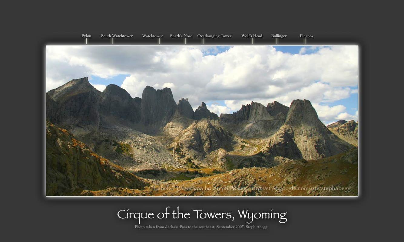
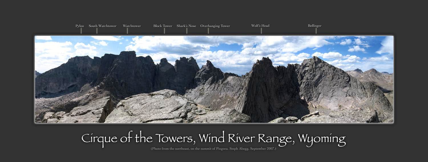
h. The view from the summit of Pingora: Block Tower, Shark's Nose, Overhanging Tower, Wolf's Head.
i. The descent involves 4 single-rope rappels to get back down to the lower buttress. A 70m rope is nice to avoid a bit of downclimbing between rappels.
j. The first rappel anchor. Despite the fact that almost everyone who comes to the Cirque climbs a route on Pingora, the rappel anchors are surprisingly manky.
k. The second rappel anchor. This one is the least manky of the four.
l. The third rappel anchor.
m. The fourth rappel anchor. This one probably wis the competition for the most manky of the four.
n. We found a smelly present at the base of the rappel route.
o. Scott took a dip in a pool just below Cirque Lake on the way back to camp. Given the icebergs that were in Cirque Lake, the temperature of this water must have been about 32°F!
p. We got back to camp at about 1pm. I had hoped that the South Buttress would simply be a warm-up for the Southwest Face (5.9) route starting just left of the rappel route, but for some reason Scott was not interested. I distracted myself from the towering gleaming granite around me by taking some flower photos. The flowers were in full bloom when we were there. Here are some indian paintbrush.
q. Another photo of indian paintbrush.
r. Some silky phacelia.
s. Sky pilot.
t. Daily.
u. White columbine.
v. White columbine. These were very plentiful in the Cirque.
w. I had to climb something, so I scrambled up the west slopes of Mitchell to the summit. Here I am on the summit of Mitchell. There is a plaque up there recording ten of Finis Mitchell's ascents from 1923 to 1973. (I had not heard of Finis Mitchell but according to Wikipedia, he served in the Wyoming House of Representatives for a few years, and eventually dedicated himself full-time to exploring and writing about the Wind River Range and over the course of his life climbed all but 20 of the 300 peaks in the range.)
x. View from the summit area of Mitchell: Warbonnet, Warrior, Pylon Pea, South Watchtower, Watchtower, Block Tower, Shark's Nose, Overhanging Tower, Wolf's Head, Bollinger Peak, Pingora.
y. I got a cell signal from the top of Mitchell and checked the weather, esigned the paperwork for my job in the fall, and answered some emails.
z. Looking down the grassy third class slopes on the west slopes of Mitchell rising above Jackass Pass. This was the quickest way up and down (1 hour up, 1 hour down).
a2. Arrowhead Lake is aptly named. In the distance are the peaks of the Deep Lake area, which was where I planned to climb after this trip.
b2. The meadowy Jackass Pass area, with the peaks of the Cirque in the distance.
c2. A black and white version of the previous.
d2. With the cell signals I was able to get from the summits and the sunny weather, my solar charger came in handy. I found a day in the sun collected at least enough power to recharge my iPhone each day.
e2. I did some night photography in the Cirque. Here is a 20 minute exposure which captures star trails and my glowing tent.
f2. Another 20 minute exposure.
Route Overlay
Photos
Photos:
a.
b.
c.
d.
e.
f.
g.
h.
i.
Photo descriptions:
a. Scott and I decided it was a good day to climb a longer route like the North Face of Mitchell. Here Scott is crossing the waterfall area in the Cirque on the approach to the north side of Mitchell. It took us an hour to get from camp to the base of the north face.
b. Looking up the north face of Mitchell. There are at least two routes on this face: the North Face Left (5.7) and the North Face Center (5.9). I lost the argument over which route to climb.
c. An old wedge/piton on the first pitch of the North Face Left route.
d. Looking down the first pitch of the North Face Left route. Dirty, wet, and ambiguous climbing was the theme for the day. This is definitely an adventure route. e. Typical cam placement on the route. f. Looking down a wet groove I led above the "bowl". There might have been a better way. But I admit, I was kind of grumpy by this point and didn't really care if there was a better way or not. I just wanted to get up as quickly as possible.
g. Finally, we escaped the North Face Left. This photo shows the true summit, which is not visible from the Cirque.
h. Scott on the "summit" that is visible from the Cirque. It was windy up here. NOAA said 33 mph gusts.
i. I did some more night photography that night. There was a half moon that cast some light on the peaks. Here's a photo of circular star trails around the North Star, which is conveniently located above the summit of Pingora.
Route Overlay
Photos
Photos:
a.
b.
c.
d.
e.
f.
g.
h.
i.
j.
k.
l.
m.
n.
o.
p.
q.
r.
Photo descriptions:
a. We woke up to another beautiful morning. Here is morning light on Warbonnet and Warrior Peaks, taken from the entrance to the upper Cirque. I had hiked up here to photograph the morning light.
b. Morning light on the peaks above Cirque Lake (Watchtower, Block Tower, Shark's Nose, Overhanging Tower).
c. Another photo of morning light on the peaks of the upper Cirque.
d. On my way back to camp, I came across a large army (14 of them!) of climbers and hikers from Albuquerque. I thought to myself: Surely someone here wants to climb! Eric and Brian were easily convinced to join me on a climb of Shark's Nose, which I'd wanted to revisit ever since Scott and my failed attempt the first day. Here Eric and Brian are headed towards the Wolf's Head-Overhanging Tower col. It had only been a few days since Scott and I had first ascended to the col, but already the snow had melted to the point that crampons were not needed.
e. Brian and Eric on the third class ramps around the west side of Overhanging Tower.
f. Another photo of Brian and Eric on the third class ramps around the west side of Overhanging Tower. This is a cool ramp system.
g. We were not enthused by the unprotected moves we identified at the start of the North Face route, so we decided to climb The Thoroughfare route, a popular 5-pitch 5.6 adventure on the NW side of the tower. Eric led off the first pitch, which is a 4th class around to the NW side. Here Brian is following the first pitch.
h. I led the second pitch up a 5.6 corner. Eric led the third pitch, which continued up the 5.6 corner. Here Eric is at the belay at the top of the third pitch.
i. Eric eagerly led the fourth pitch up the steep cracks which seemed a little harder than 5.6 for the first couple of moves but then eased off. The climbing was quite fun on this route.
j. A view of the rugged summits to the southeast.
k. Looking down on Wolf's Head and Pingora from the summit of Shark's Nose.
l. To descend, we rappelled the route. We made three double rope rappels. The anchors were of the "more slings the better" type. m. The rap anchors are largely connected to the rock by old pitons.
n. Eric and Brian at the third of our rappel anchors. The double rope raps had gone smoothly to here. Despite Eric's wise comment that we probably should resort to single rope rappels from here on out due to the more blocky nature of the route, we lazily made the mistake of another double rope rap....
o. ...and got the rope stuck. Some sketchy soloing schenanegans and about an hour later, we finally had the ropes free. I resorted to single rope rappels to get back down to Eric and Brian at the base, and even then the rope was determined to get stuck. Shown in this photo, it almost pulled a 40-lb rock down on Eric.
p. Understandably tired of the dangers of rappelling, we decided to downclimb from the top of the first pitch. Here Eric is waving from the notch that marks the top of the first pitch.
q. When we got back to the col, we discovered that marmots find trekking poles tasty.
r. Mitchell Peak above Cirque Lake on the hike back to camp. It had been a fun full day of alpine adventuring. By the time we got back to the lower Cirque, Eric was putting the bug in my ear about a long route on Pingora the next day. Admittedly, over 1000 vertical feet of 5.7 splitter cracks and corners sounded like pure fun....
Route Overlay
Photos
Photos:
a.
b.
c.
d.
e.
f.
g.
h.
i.
Photo descriptions:
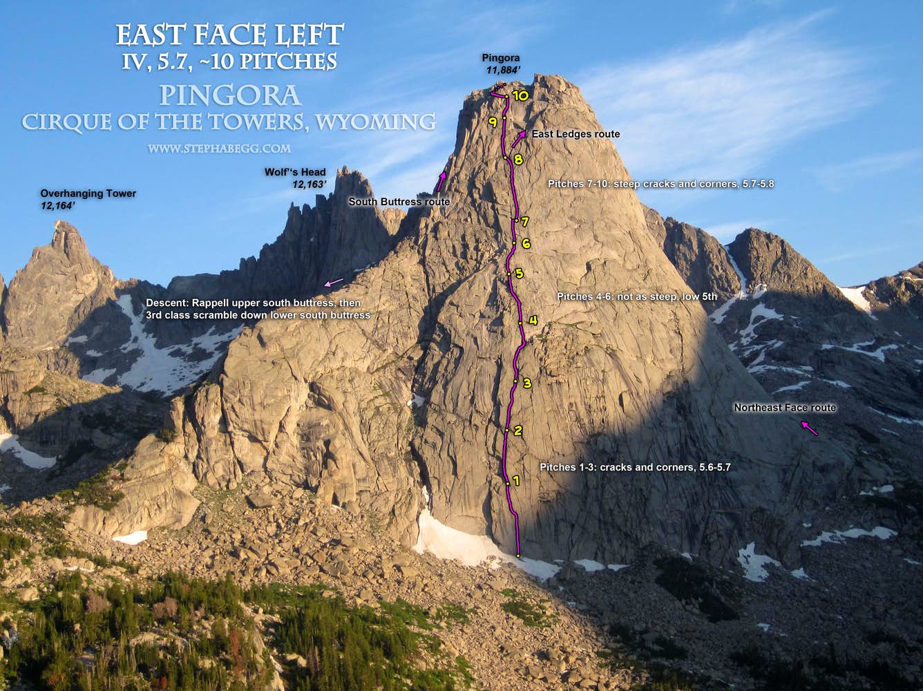
a. It was another beautiful day for yoga in camp, so Eric and I teamed up to climb the East Face route on Pingora, which takes an aesthetic line all the way from the toe to the top. This route is just as long as the classic Northeast Face route (which I had climbed in 2007), but slightly easier.
b. Looking up the base of the route. We took the left crack in this photo.
c. An old hex en route.
d. Eric led a few of the pitches and I led the rest. Here he is leading the seventh pitch, which brought us to the base of the steeper final headwall pitches.
e. Eric climbing up the eighth pitch, with Lonesome Lake far below.
f. Looking down while climbing the steep and sustained corner of hadcracks on the ninth pitch. This was my favorite pitch of the route.
g. Looking down at Cirque Lake from the summit. The lowest iceberg looks like of like a fish.
h. Eric on the rappel route.
i. Still there. The plastic bag was preserving the contents nicely.
Route Overlay
Photos
Photos:
a.
b.
c.
d.
e.
f.
g.
h.
i.
j.
k.
l.
m.
n.
o.
p.
q.
r.
Photo descriptions:
a. Morning sun on South Watchtower and Watchtower. Another nice day! We really nailed the weather forecast on our trip.
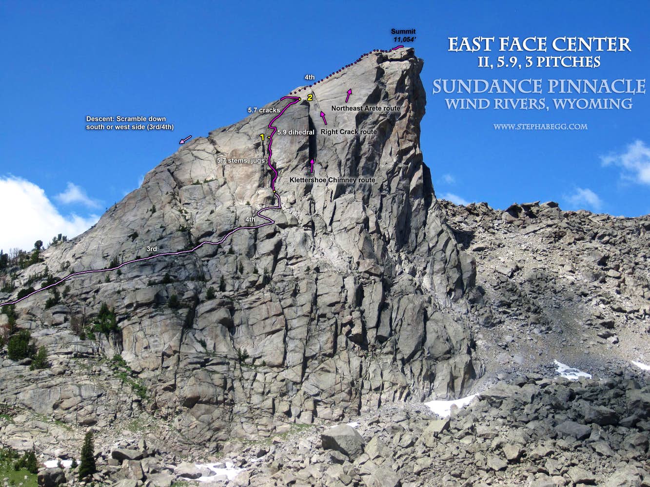
b. Scott wanted another rest day (I'd given up speculating reasons for his desire to hang out with the mosquitos while there were gleaming granite spires towering around us), so I joined Alubquerqueians Bill and Claire on an adventure to climb Sundance Pinnacle. This is the hunk of solid granite that is seen above the southwest side of North Lake on the approach to the Cirque. Here Bill and Claire are in the Field of Giant Boulders on the west side of North Lake. By this time, we were realizing it would have been much faster to just take the trail around the east side of the lake....
c. A view of the Field of Giant Boulders. Many of these boulders are the size of a small house.
d. There were lots of spiders hanging out amongst the boulders. Preserving spider webs while negotiating the boulders became quite the route-finding challenge!
e. There were three 5.9 routes on Sundance Pinnacle we were considering: East Face Center, Klettershoe Chimney, and Right Crack. Two of them (Klettershoe Chimney or Right Crack) require some larger gear. We brought the larger cams with us on the approach, but when we got to the base we decided to climb the East Face Center route which had more roomy belay ledges and less intimidating climbing (this would be Claire's second significant multipitch alpine climb, her first being the South Buttress of Pingora a few days earlier).
f. Getting to the base of the routes on Sundance involves traversing 3rd class ledges from the south. There were a couple of exposed moves.
g. Bill leading off the first pitch, a surprisingly fun pitch of sustained steep and juggy 5.7 corner climbing.
h. Looking down from midway up the first pitch.
i. The start of Pitch 2 features the crux of this route, a 5.9 fingers to layback corner. I led this pitch. Despite being a bit licheny, the climbing in the corner was really good.
j. The top of the second pitch joins the top of the Klettershoe Chimney route. This photo is taken looking down the Klettershoe Chimney (right in photo) and Right Crack (left in photo) routes.
k. Bill and Claire on top of Sundance Pinnacle, with the Warbonnet massive behind.
l. Bill and Claire beginning the descent from Sundance Pinnacle. We scrambled down the south side. With careful route-finding, we managed to find a mostly 3rd class (with a little 4th class) way down.
m. We took a break in the meadow below the south side of Sundance Pinnacle. The terrain to the south and west of Sundance is really quite magical.
n. We got a good view of the Deep Lake area to the east. In this photo are Haystack, Steeple Peak, East Temple Peak, and Temple Peak.
o. On the way back into the Cirque, we had fun coming up with names for the rocky knoll that is at the head of the lower Cirque, in front of Overhanging Tower in this photo. Some propositions: "Spider Bump", "Transformer Knob", "Gollum's Lair", "Chromosome Knoll",...
p. Does anyone else see Darth Vader?
q. I really enjoyed hanging out with the friendly mob from Albuquerque. Thanks guys for welcoming me into your group.
r. Evening light on Mitchell, Warbonnet, and Warrior. It was sad to say goodbye to the Cirque, but I would definitely be back. Ironically, even though I had climbed all six days I had been there and had a great trip, I had not climbed one route that Scott and I had come in to climb. Oh well, I'll just take that as a reason to come back!
Useful beta. Updated route information. Corrections. Historical notes. Interesting facts. No fluff please. Please do not put links in your comment, as my spam filter will filter those comments out.