Morning Star Peak, Mile High Club (5.10-, 700′)

Morning Star Peak

Route:

Mile High Club

5.10-, 700'

Enjoyable afternoon of "alpine cragging" in the North Cascades.

Region: Washington
Elev: 5,280 ft
Rock type: Metamorphosed Sandstone
Type: 
Date(s): June 19, 2016 (Sun)
Partner(s): Sam Bedell

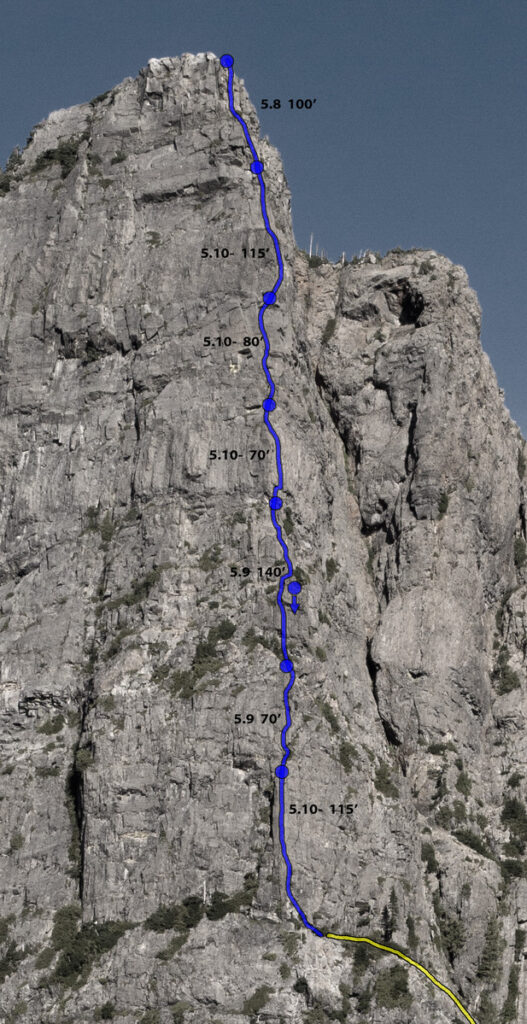
Route Overlay 

(from Rad and Dan's Original Trip Report)

CLICK TO ENLARGE

Intro

Sam and I had initially planned to crag at Index for the day, but at the last minute (actually on the drive to Index) we decided to check out Mile High Club, a route that had been established the previous year (Sept 2015) by Darin Berdinka and Rad Roberts ascending a 700' pillar on a sub-summit of Morning Star Peak. The route features seven pitches of excellent exposed face climbing on the sun-drenched crest of the pillar. Unique to the North Cascades, Mile High Club is fully bolted, so all you need for protection is a dozen draws and a rope. To descend, you rap the route (single 70 or two 60s), so you can even leave your shoes and approach gear at the base. Combined with the reasonably short approach, this route makes for a fun and fairly low commitment day of "alpine cragging."

As Darin and Rad note in their trip report for the first ascent, the sub-summit is 5,280 feet above sea level, which inspired the name of the route. The link to the first ascent trip report also provides updates for the climb in the comments that follow the report, so I would advise checking out the comments before you climb the route. Also, this route is detailed in Blake Herrington's new (as of 2016) Cascades Rock guidebook, so check that out for more detail.

Because of the last minute change in plans, we got a fairly late start (left the trailhead at around 11:15am), but we were climbing by 1:30pm, on the summit by 4:00pm, and back at the base at 5:30pm, and back to the car by 7:30pm. We found Mile High Club to be fun, exposed, and sustained at the 5.9-5.10a grade. The rock is a metamorphosed sandstone which is generally solid, has good friction, and is littered with positive holds. The route is well-bolted and never felt dangerously runnout, although it is ledgy enough that you don't want to fall. It was a enjoyable afternoon of "alpine cragging" in the North Cascades.

We were the first party of the season and the 15th party ever to join the ranks of the Mile High Club.

The following page gives a route overlay (from Rad and Darin's original trip report for the route) and some of my photos from our climb of the route.

Photos

THIS TRIP REPORT IS STILL MOSTLY IN THE EMBEDDED HTML FORMAT OF MY OLD WEBSITE.

PhotosPhoto descriptions
1.    
2.    
3.    
4.    
5.    
6.    
7.    
8.    
9.    
10.    
11.    
12.    
13.    
14.    
15.    
16.    
17.    
18.    
19.    
20.    
21.    
1. Creek crossing on the trail up to Headlee Basin.
2. The view of the pinnacle from the trail up to Headlee Pass. We were a bit worried since it looked like the rock was still wet from the previous day's rainshowers, but fortunately the route on the crest of the pinnacle turned out to be mostly dry with just a few short wet sections. 
3. Looking ahead at the easy traverse to the base of the pinnacle. We left the trail at the end of the last major switchback before the trail began to head up to Headlee Pass.
4. Sam starting up Pitch 1 (10a). The start was a little wet but the rest was dry. And fun!
5. Looking up the steep juggy 10a climbing at the start of Pitch 1.
6. Pitch 2 (5.9) continues up the featured rock on the crest.
7. Sam staring up Pitch 3 (5.9).
8. Pitch 4 (10a).
9. The 5.10a dihedral of Pitch 5.
10. Looking down while leading the airy arete of Pitch 6 (10a). Fantastic exposure on this pitch.
11. Sam starting up Pitch 7 (5.8), which takes you to the top.
12. A bolt on the route. The route is fully bolted, so you can leave the cams at home. A long fall on this kind of ledgy terrain would not be pleasant, so we appreciated the nice density of bolts on the route. The bolts were comfortably spaced and nowhere felt dangerously runnout. As the photo shows, the metamrphosed sandstone rock on the route is grippy.
13. Sam on the mile-high summit of the pinnacle. The true summit of Morning Star Peak behind.
14. We were the first party of the season and the 15th party ever to join the ranks of the Mile High Club.
15. Del Campo to the southeast.
16. Vesper to the west. There are some descent tracks coming down from the summit. We climbed Vesper's north side the next day and descended the east side seen in this photo.
17. Some rock to the east. Wonder if anyone has checked it out for route potential....
18. The rap station on the summit. To descend, we rappelled the route with 8 single-rope (with a 70m rope) rappels. All the rappels used the bolted anchors at the end of each pitch, along with an intermediate rappel midway up Pitch 3.
19. Sam rappelling.
20. Another view of the buttress, taken from the trail on the hike out.
21. A view into Headlee Basin from the Sunrise Mine Road. Mile High Club ascends the buttress in profile on the left.

Comments Pertaining to this Page / Trip Report

Useful beta. Updated route information. Corrections. Historical notes. Interesting facts. No fluff please.
Leave a Reply

Your email address will not be published. Required fields are marked *